Sha Tin District
|
Sha Tin 沙田區 |
||
|---|---|---|
| District | ||
| Sha Tin District | ||

Day view of the Sha Tin District skyline
|
||
|
||
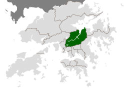
 Location of Sha Tin District within Hong Kong |
||
| Coordinates: 22°23′14″N 114°11′43″E / 22.38715°N 114.19534°ECoordinates: 22°23′14″N 114°11′43″E / 22.38715°N 114.19534°E | ||
| Country |
|
|
| Region | New Territories | |
| Constituencies | 36 | |
| Government | ||
| • District Council Chairman | Ho Hau-cheung, BBS, MH (Civil Force) | |
| Area | ||
| • Total | 69.4 km2 (26.8 sq mi) | |
| Population (2011) | ||
| • Total | 630,273 | |
| • Density | 9,173/km2 (23,760/sq mi) | |
| Time zone | Hong Kong Time (UTC+8) | |
| Website | Sha Tin District Council | |
| Sha Tin District | |||||||||||||||
| Traditional Chinese | 沙田區 | ||||||||||||||
|---|---|---|---|---|---|---|---|---|---|---|---|---|---|---|---|
| Simplified Chinese | 沙田区 | ||||||||||||||
| Literal meaning | "sand field district" | ||||||||||||||
|
|||||||||||||||
| Transcriptions | |
|---|---|
| Standard Mandarin | |
| Hanyu Pinyin | Shātián Qū |
| Yue: Cantonese | |
| Yale Romanization | Sā tìhn kēui |
| IPA | [sátʰȉn kʰœ́y] |
| Jyutping | Saa1 tin4 keoi1 |
Sha Tin District is one of the 18 districts of Hong Kong. As one of the 9 districts located in the New Territories, it covers the areas of Sha Tin, Tai Wai, Ma On Shan, Fo Tan, Siu Lek Yuen and Ma Liu Shui. The district is the most populous district in Hong Kong, with a population of 630,273.
The Sha Tin District covers approximately 69.4 km² (26.8 sq. mi), including Sha Tin New Town and several country parks. Built mostly on reclaimed land in Sha Tin Hoi, the well-developed Sha Tin New Town comprises mainly residential areas along the banks of the Shing Mun River Channel. In the early 1970s it was a rural township of about 30,000 people. After Sha Tin's first public housing estate, Lek Yuen Estate, was completed in 1976, the settlement began to expand. Today, about 65% of the district's population live in public rental housing, housing under Hong Kong's Tenants Purchase Scheme, or Home Ownership Scheme.
Sha Tin was formerly named Lek Yuen, literally meaning the "source of trickling" or "source of clear water". The area of the present day Sha Tin was populated before the Ming Dynasty. As the Shing Mun River runs across the district, most local residents were farmers and relied on agriculture for living. In 1579, Tai Wai Village, the oldest and largest walled village in the district was built. Several other villages were built along the river after Tai Wai Village.
Sha Tin started to be administered by the British Hong Kong government since the Convention for the Extension of Hong Kong Territory was signed. The establishment of the Sha Tin Station of the Kowloon-Canton Railway (British Section) in 1910 caused Sha Tin to be the more common name for the area, replacing Lek Yuen ever since.
...
Wikipedia

