Ma On Shan (area)
| Ma On Shan | |||||||||||

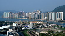
A view of Ma On Shan and the Tolo Harbour
|
|||||||||||
| Traditional Chinese | 馬鞍山 | ||||||||||
|---|---|---|---|---|---|---|---|---|---|---|---|
| Simplified Chinese | 马鞍山 | ||||||||||
| Literal meaning | Saddle Hill | ||||||||||
|
|||||||||||
| Transcriptions | |
|---|---|
| Standard Mandarin | |
| Hanyu Pinyin | Mǎ'ānshān |
| Yue: Cantonese | |
| Jyutping | maa5 on1 saan1 |
Coordinates: 22°25′19.41″N 114°13′56.66″E / 22.4220583°N 114.2324056°E
Ma On Shan is a new town along the eastern coast of Tolo Harbour in the New Territories of Hong Kong. Although it was initially an extension of Sha Tin New Town, it has its own town centre and various government facilities, and is now classified as a separate new town in government reports. Administratively, it belongs to Sha Tin District.
Ma On Shan is located by the west face of the twin peaks of Ma On Shan, which can be translated as "horse saddle mountain". The town is built on the strip between Tolo Harbour and Ma On Shan mountain. The north end of the town reaches the settlement of Wu Kai Sha and the southern Tai Shui Hang.
The original Ma On Shan Village still houses around 80 families. Yan Kwong Lutheran Church, one of two original churches established during the area's mining heyday, was revitalised in around 2014 as a centre to highlight the history and culture of the old village.
Deep inside the slope of Ma On Shan was an iron mine. The mine was long abandoned before the more recent new town development. The quarrying workers spoke a language which is a combination of various languages in Southern China.
...
Wikipedia
