Serangoon Road Race Course
| Farrer Park | |
|---|---|
| Name transcription(s) | |
| • Chinese | 花拉公园 |
| • Pinyin | Huālā gōngyuán |
| • Malay | Taman Farrer |
| • Tamil | ஃபேரர் பார்க் |

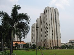
Farrer Park in 2006
|
|
| Country | Singapore |
Farrer Park is a subzone of the Rochor planning area in the Central Region of Singapore, bounded by Serangoon Road, Rangoon Road, Race Course Road, Northumberland Road, Tekka Lane and Bukit Timah Road.
It is worth noting that this article is about the Farrer Park subzone, part of the Rochor planning area as defined by the Urban Redevelopment Authority (URA). Historically, the name "Farrer Park" referred to an open field situated to the west of this subzone. This open field is now commonly known as "Farrer Park Field" and is located within Kallang planning area.
Farrer Park and Farrer Road were named after R. J. Farrer (died 1956), who was Municipal Assessor and later President of the Municipal Commissioners in the 1920s. In 1952, there was an abortive attempt to change the name of Farrer Road in order to avoid confusion with Farrer Park, situated in a different location.
It was at Farrer Park that Singapore's first racecourse was built and where the island's aviation history began.[1]
The Serangoon Road Race Course was established at Farrer Park in December 1842 and was run by the Singapore Sporting Club. Horse races were held mostly on weekends and attracted a largely European audience. On non-race days, the Racecourse's large turf doubled as a golf course, grazing pasture and rifle range. Staffing the Racecourse were Baweanese settlers from Java in Indonesia. A sizeable Indian community also lived in the Farrer Park area; they were workers and owners of the cattle farms, rattan processing houses and pineapple factories in the vicinity. It was these cattle farms which gave the area its Malay name of Kandang Kerbau, or Buffalo Shed.
...
Wikipedia
