Sauk Village, Illinois
| Sauk Village, Illinois | |
| Known as Strassburg from 1839-1957 | |
| Village | |
| Official name: Village of Sauk Village | |
| Motto: Pride and Progress | |
| Country | United States |
|---|---|
| State | Illinois |
| Counties | Cook, Will |
| Coordinates | 41°29′19″N 87°33′56″W / 41.48861°N 87.56556°WCoordinates: 41°29′19″N 87°33′56″W / 41.48861°N 87.56556°W |
| Area | 3.87 sq mi (10 km2) |
| - land | 3.84 sq mi (10 km2) |
| - water | 0.04 sq mi (0 km2) |
| Population | 10,506 (2010) |
| Density | 2,735.9/sq mi (1,056/km2) |
| Founded | 1842 (Incorporated on March 12, 1957) |
| Government | Mayor (Village President) and Village Board of Trustees |
| Mayor/Village President | David A. Hanks (2012-2017) |
| Timezone | CST (UTC-6) |
| - summer (DST) | CDT (UTC-5) |
| Postal code | 60411 |
| Area code | 708 |
|
Location in Cook County and the state of Illinois.
|
|
|
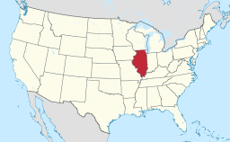
Location of Illinois in the United States
|
|
|
Website: www |
|
Sauk Village is a village in Cook County, Illinois, United States, with a small portion in Will County. The population was 10,506 at the 2010 census.
Sauk Village is located at 41°29′19″N 87°33′56″W / 41.48861°N 87.56556°W (41.488535, -87.565658).
According to the 2010 census, Sauk Village has a total area of 3.878 square miles (10.04 km2), of which 3.84 square miles (9.95 km2) (or 99.02%) is land and 0.038 square miles (0.10 km2) (or 0.98%) is water.
The village stands on the Tinley Moraine. The Glenwood Shoreline cuts through the village.
Neighboring towns include the Illinois communities of Lynwood to the northeast, Ford Heights to the north, Chicago Heights to the northwest, South Chicago Heights to the west, Steger to the southwest, and Crete to the south. The town of Dyer, Indiana, is the nearest community to the east.
As of the census of 2010, there were 10,506 people (10,559 based on census data July, 2012), 3,685 households, 2,525 families residing in the village. The population density was 2,737.2 people per square mile (1,057.8/km²). There were 3,685 housing units, 3,226 occupied, at an average density of 924.1 per square mile (357.1/km²). The racial makeup of the village was 28.80% White, 62.79% African American, 1.00% Native American, 0.50% Asian, 0.01% Pacific Islander, 5.90% from other races. Additionally, Hispanic or Latino of any race were 11.10% of the population.
...
Wikipedia


