Saint Lawrence Valley
| Saint Lawrence River | |
| Fleuve Saint-Laurent, Fleuve St-Laurent, St-Lawrence River, St-Laurent River | |
|
Saint Lawrence River near Alexandria Bay
|
|
| Name origin: Saint Lawrence of Rome | |
| Countries | Canada, United States |
|---|---|
| Provinces | Ontario, Quebec |
| State | New York |
| Source | Lake Ontario |
| - location | Kingston, Ontario / Cape Vincent, New York |
| - elevation | 74.7 m (245 ft) |
| - coordinates | 44°06′N 76°24′W / 44.100°N 76.400°W |
| Mouth | Gulf of St. Lawrence / Atlantic Ocean |
| - elevation | 0 m (0 ft) |
| - coordinates | 49°30′N 64°30′W / 49.500°N 64.500°WCoordinates: 49°30′N 64°30′W / 49.500°N 64.500°W |
| Length | 500 km (310 mi) Excluding the estuary. Ca. 1200 km if included. |
| Basin | 1,344,200 km2 (519,000 sq mi) |
| Discharge | for below the Saguenay River |
| - average | 16,800 m3/s (590,000 cu ft/s) |
|
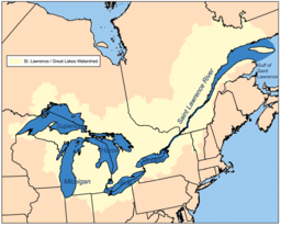
Map of the Saint Lawrence/Great Lakes Watershed
|
|
The Saint Lawrence River (French: Fleuve Saint-Laurent; Tuscarora: Kahnawáʼkye;Mohawk: Kaniatarowanenneh, meaning "big waterway") is a large river in the middle latitudes of North America. The Saint Lawrence River flows in a roughly north-easterly direction, connecting the Great Lakes with the Atlantic Ocean and forming the primary drainage outflow of the Great Lakes Basin. It traverses the Canadian provinces of Quebec and Ontario, and is part of the international boundary between Ontario, Canada, and the U.S. state of New York. This river also provides the basis of the commercial Saint Lawrence Seaway.
The Saint Lawrence River begins at the outflow of Lake Ontario and flows through Gananoque, Brockville, Morristown, Ogdensburg, Massena, Cornwall, Montreal, Trois-Rivières, and Quebec City before draining into the Gulf of Saint Lawrence, the largest estuary in the world. The estuary begins at the eastern tip of Île d'Orléans, just downstream from Quebec City. The river becomes tidal around Quebec City.
...
Wikipedia


