Saarbruecken
| Saarbrücken | ||
|---|---|---|

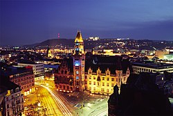
Saarbrücken in January 2006
|
||
|
||
|
Location of Saarbrücken within Saarbrücken district
|
||
| Coordinates: 49°14′N 7°0′E / 49.233°N 7.000°ECoordinates: 49°14′N 7°0′E / 49.233°N 7.000°E | ||
| Country | Germany | |
| State | Saarland | |
| District | Saarbrücken | |
| Government | ||
| • Mayor | Charlotte Britz (SPD) | |
| Area | ||
| • City | 167.07 km2 (64.51 sq mi) | |
| Elevation | 230.1 m (754.9 ft) | |
| Population (2016-12-31) | ||
| • City | 179,709 | |
| • Density | 1,100/km2 (2,800/sq mi) | |
| • Urban | 329,593 | |
| • Metro | 700,000 | |
| Time zone | CET/CEST (UTC+1/+2) | |
| Postal codes | 66001–66133 | |
| Dialling codes | 0681, 06893, 06897, 06898, 06805 | |
| Vehicle registration | SB | |
| Website | www.saarbruecken.de | |
| Largest groups of foreign residents | |
| Country of birth | Population (2014) |
|---|---|
|
|
3,851 |
|
|
2,292 |
|
|
2,245 |
|
|
1,555 |
|
|
1,000 |
Saarbrücken (German pronunciation: [zaːɐ̯ˈbʁʏkn̩] (![]() listen), French: Sarrebruck[saʁbʁyk], Rhine Franconian: Saarbrigge [zaːˈbʁɪgə]) is the capital and largest city of the state of Saarland, Germany. Saarbrücken is Saarland's administrative, commercial and cultural centre. The city is situated next to the French border at the heart of the metropolitan area of Saarland.
listen), French: Sarrebruck[saʁbʁyk], Rhine Franconian: Saarbrigge [zaːˈbʁɪgə]) is the capital and largest city of the state of Saarland, Germany. Saarbrücken is Saarland's administrative, commercial and cultural centre. The city is situated next to the French border at the heart of the metropolitan area of Saarland.
Saarbrücken was created in 1909 by the merger of three towns, Saarbrücken, St. Johann, and Malstatt-Burbach. It used to be the industrial and transport centre of the Saar coal basin. Products included iron and steel, sugar, beer, pottery, optical instruments, machinery, and construction materials.
Historic landmarks in the city include the stone bridge across the Saar (1546), the Gothic church of St. Arnual, the 18th-century Saarbrücken Castle, and the old part of the town, the Sankt Johanner Markt (Market of St. Johann).
Twice in the 20th century Saarbrücken was separated from Germany: in 1920–35 as capital of the Territory of the Saar Basin and in 1947–56 as capital of the Saar Protectorate.
...
Wikipedia


