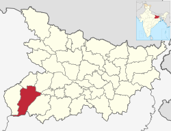
Rohtas district
|
Rohtas district रोहतास ज़िला روہتاس ضلع |
|
|---|---|
| District of Bihar | |
 Location of Rohtas district in Bihar |
|
| Country | India |
| State | Bihar |
| Administrative division | Patna |
| Headquarters | Sasaram |
| Government | |
| • Lok Sabha constituencies | Sasaram, Karakat |
| Area | |
| • Total | 3,847.82 km2 (1,485.65 sq mi) |
| Population (2011) | |
| • Total | 2,962,593 |
| • Density | 770/km2 (2,000/sq mi) |
| Demographics | |
| • Literacy | 82.94 per cent |
| • Sex ratio | 950 |
| Major highways | NH 2 |
| Website | Official website |
Rohtas district (Hindi: रोहतास ज़िला; Urdu: روہتاس ضلع) is one of the thirty-eight districts of Bihar state, India. It came into existence when Shahabad District was bifurcated into Bhojpur & Rohtas in 1972.
The Rohtas district is a part of Patna Division, and it has an area of 3850 km² (square kilometres), a population of 2,448,762 (2001 census), and a population density of 636 persons per km². The languages spoken in this area are Bhojpuri, Hindi and English.
The administrative headquarters of the district, Sasaram is a place of historical importance. Another important symbol of national pride are the parallel bridges built over the Sone River – one for road and another for railway. The road bridge (Jawahar Setu built by Gammon India in 1963–65) over Sone was the longest (3061 m) in Asia until it was surpassed by the Mahatma Gandhi setu (5475 m) over the river Ganges at Patna. Nehru Setu, the railway bridge is the second longest railway bridge in India.
The district is also home to the Rohtasgarh fort, which was one of the strongest forts in the medieval age.
The district is currently a part of the Red Corridor.
Rohtas district occupies an area of 3,851 square kilometres (1,487 sq mi).
The district has a variety of landscapes within a small area, with flat plains running alongside the Kaimur Range and Rohtas Plateau. The majority of the land is a fertile floodplain of the Son River which is a tributary of the Ganges originating in Madhya Pradesh. The mountains of the Kaimur Range, which is an extension of the Vindhya Range were heavily forested in recent history, however mass deforestation has occurred due to firewood being used as fuel. The area is highly fertile and due to this is densely populated.
...
Wikipedia
