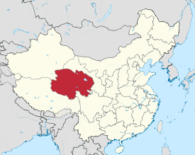
Qinghai Province
|
Qinghai Province 青海省 |
|
|---|---|
| Province | |
| Name transcription(s) | |
| • Chinese | 青海省 (Qīnghǎi Shěng) |
| • Abbreviation | (pinyin: Qīng) |
 Map showing the location of Qinghai Province |
|
| Coordinates: 35°N 96°E / 35°N 96°ECoordinates: 35°N 96°E / 35°N 96°E | |
| Named for | Derived from the name of Qinghai Lake ("blue/green lake"). |
| Capital (and largest city) |
Xining |
| Divisions | 8 prefectures, 43 counties, 429 townships |
| Government | |
| • Secretary | Wang Guosheng |
| • Governor | Wang Jianjun |
| Area | |
| • Total | 720,000 km2 (280,000 sq mi) |
| Area rank | 4th |
| Population (2010) | |
| • Total | 5,626,722 |
| • Rank | 30th |
| • Density | 7.8/km2 (20/sq mi) |
| • Density rank | 30th |
| Demographics | |
| • Ethnic composition |
Han - 54% Tibetan - 21% Hui - 16% Tu - 4% Mongol - 1.8% Salar - 1.8% |
| • Languages and dialects | Zhongyuan Mandarin-Chinese, Amdo Tibetan, Monguor, Oirat Mongolian, Salar, and Western Yugur |
| ISO 3166 code | CN-63 |
| GDP (2016) |
CNY 0.26 billion USD 387 billion (30th) |
| • per capita |
CNY 43,718 USD 6,583 (17th) |
| HDI (2010) | 0.638 (medium) (27th) |
| Website |
http://www.qh.gov.cn/ (Simplified Chinese) |
| Qinghai | |||||||||||||||||||||||||||||||||||

"Qinghai" in Chinese characters
|
|||||||||||||||||||||||||||||||||||
| Chinese name | |||||||||||||||||||||||||||||||||||
|---|---|---|---|---|---|---|---|---|---|---|---|---|---|---|---|---|---|---|---|---|---|---|---|---|---|---|---|---|---|---|---|---|---|---|---|
| Chinese | 青海 | ||||||||||||||||||||||||||||||||||
| Postal | Tsinghai | ||||||||||||||||||||||||||||||||||
| Literal meaning | "Azure Sea" | ||||||||||||||||||||||||||||||||||
|
|||||||||||||||||||||||||||||||||||
| Tibetan name | |||||||||||||||||||||||||||||||||||
| Tibetan | མཚོ་སྔོན་ | ||||||||||||||||||||||||||||||||||
|
|||||||||||||||||||||||||||||||||||
| Mongolian name | |||||||||||||||||||||||||||||||||||
| Mongolian script | ᠬᠥᠬᠡ ᠨᠠᠭᠤᠷ | ||||||||||||||||||||||||||||||||||
|
|||||||||||||||||||||||||||||||||||
| Manchu name | |||||||||||||||||||||||||||||||||||
| Romanization | Huhu Noor | ||||||||||||||||||||||||||||||||||
| Oirat name | |||||||||||||||||||||||||||||||||||
| Oirat | Kokonur | ||||||||||||||||||||||||||||||||||
| Transcriptions | |
|---|---|
| Standard Mandarin | |
| Hanyu Pinyin | Qīnghǎi |
| Bopomofo | ㄑㄧㄥ ㄏㄞˇ |
| Gwoyeu Romatzyh | Chinghae |
| Wade–Giles | Chʻing1-hai3 |
| IPA | [tɕʰíŋxài̯] |
| Wu | |
| Romanization | Tshin平-he上 |
| Hakka | |
| Romanization | Tshiâng-hói |
| Yue: Cantonese | |
| Yale Romanization | Chīng-hói |
| Jyutping | Cing1-hoi2 |
| Southern Min | |
| Hokkien POJ | Chheng-hái |
| Tâi-lô | Tsheng-hái |
| Transcriptions | |
|---|---|
| Wylie | mtsho sngon |
| Transcriptions | |
|---|---|
| SASM/GNC | Köke naɣur |
Qinghai (Chinese: 青海; pronounced [tɕʰíŋxài̯]), formerly known in English as Kokonur, is a province of the People's Republic of China located in the northwest of the country. As one of the largest province-level administrative divisions of China by area, the province is ranked fourth-largest in size, but has the third-smallest population.
Located mostly on the Tibetan Plateau, the province has long been a melting pot for a number of ethnic groups including the Han, Tibetans, Hui, Tu, Mongols, and Salars. Qinghai borders Gansu on the northeast, Xinjiang on the northwest, Sichuan on the southeast, and the Tibet Autonomous Region on the southwest. Qinghai province was established in 1928 under the Republic of China period during which it was ruled by Chinese Muslim warlords known as the Ma clique. The Chinese name, "Qinghai" is named after Qinghai Lake (cyan sea lake), the largest lake in China. The province was known formerly as Kokonur in English, derived from the Oirat name for Qinghai Lake.
...
Wikipedia
