Province of Huelva
| Huelva | |||
|---|---|---|---|
| Province | |||

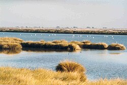
A wetland area of Donana National Park
|
|||
|
|||
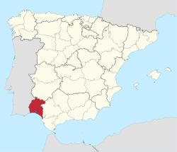
 Map of Spain with Huelva highlighted |
|||
| Coordinates: 37°33′N 6°55′W / 37.550°N 6.917°WCoordinates: 37°33′N 6°55′W / 37.550°N 6.917°W | |||
| Country | Spain | ||
| Autonomous community |
|
||
| Capital | Huelva | ||
| Area | |||
| • Total | 10,148 km2 (3,918 sq mi) | ||
| Area rank | Ranked | ||
| Population (2013) | |||
| • Total | 483,792 | ||
| • Rank | Ranked | ||
| • Density | 48/km2 (120/sq mi) | ||
| Official language(s) | Spanish | ||
| Parliament | Cortes Generales | ||
Huelva (pronounced: [ˈwelβa]) is a province of southern Spain, in the western part of the autonomous community of Andalusia. It is bordered by Portugal, the provinces of Badajoz, Seville, and Cádiz, and the Atlantic Ocean. Its capital is Huelva.
Its area is 10,148 km². Its population is 483,792 (2005), of whom about 30% live in the capital, and its population density is 47.67/km². It contains 79 municipalities.
The economy is based on agriculture and mining. The famous Rio Tinto mines have been worked since before 1000 BC, and were the major source of copper for the Roman Empire. As an indication of the scope of ancient mining, sixteen million tons of Roman slag have been identified at the Roman mines. British companies resumed large-scale mining in 1873; the district is the namesake of the Rio Tinto Group.
The province contains Palos de la Frontera, and Moguer, where Christopher Columbus sailed out of on his first voyage in 1492, and shares the Parque Nacional de Doñana.
The delayed tourist development of the province has allowed better city planning than in other regions on the Spanish coast. The nuclei of Islantilla and Isla Canela are an example of this attempt to plan in a more coherent form. Although in a smaller scale in comparison to other regions, urban pressure continues. Previous developments that had little planning until recent time are El Rompido, El Portil, Mazagón and Matalascañas (Torre de la Higuera).
...
Wikipedia


