Princely Countess of Gorizia and Gradisca
| Princely County of Gorizia and Gradisca | ||||||||||||
| Gefürstete Grafschaft Görz und Gradisca | ||||||||||||
|
State of the Holy Roman Empire (until 1806) Crown land of the Austrian Empire (until 1867) Cisleithanian crown land of Austria-Hungary |
||||||||||||
|
||||||||||||
|
||||||||||||
|
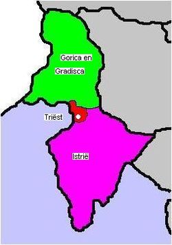
Map of the Austrian Littoral, comprising the Imperial Free City of Trieste (red), the Margravate of Istria (purple), and the Princely County of Gorizia and Gradisca (green)
|
||||||||||||
| Capital | Gorizia | |||||||||||
| Languages | Slovene, Italian, Friulian, German | |||||||||||
| Religion | Roman Catholic | |||||||||||
| Government | Principality | |||||||||||
| Emperor of Austria | ||||||||||||
| • | 1848–1916 | Franz Joseph I | ||||||||||
| • | 1916–1918 | Karl I | ||||||||||
| Landeshauptmann | ||||||||||||
| • | 1870–1877 | Francesco Coronini | ||||||||||
| • | 1877–1883 | Luigi Pajer de Monriva | ||||||||||
| • | 1883–1899 | Franz Graf von Coronini-Cronberg | ||||||||||
| • | 1899–1913 | Luigi Pajer de Monriva | ||||||||||
| Historical era | Modern history | |||||||||||
| • | Established | 4 March 1754 | ||||||||||
| • | Treaty of Saint-Germain | 10 September 1919 | ||||||||||
| Area | ||||||||||||
| • | 1880 | 2,918 km² (1,127 sq mi) | ||||||||||
| Population | ||||||||||||
| • | 1880 est. | 211,000 | ||||||||||
| Density | 72.3 /km² (187.3 /sq mi) | |||||||||||
| • | 1910 est. | 260,721 | ||||||||||
| Density | 89.3 /km² (231.4 /sq mi) | |||||||||||
|
||||||||||||
The Princely County of Gorizia and Gradisca (German: Gefürstete Grafschaft Görz und Gradisca; Italian: Principesca Contea di Gorizia e Gradisca; Slovene: Poknežena grofija Goriška in Gradiščanska) was a crown land of the Habsburg dynasty within the Austrian Littoral on the Adriatic Sea, in what is now a multilingual border area of Italy and Slovenia. It was named for its two major urban centers, Gorizia and Gradisca d'Isonzo.
The province stretched along the Soča/Isonzo River, from its source at Mt. Jalovec in the Julian Alps down to the Gulf of Trieste near Monfalcone. In the northwest, the Predil Pass led to the Duchy of Carinthia, in the northeast Mts. Mangart, Razor and Triglav marked the border with the Duchy of Carniola (Upper Carniola).
In the west, Mts. Kanin and Matajur stood on the border with the Friulian region, which until the 1797 Treaty of Campo Formio was part of the Republic of Venice, from 1815 onwards belonged to the Austrian Kingdom of Lombardy–Venetia and finally to the re-established Kingdom of Italy from 1866. In the south the province bordered on the territory of the Imperial Free City of Trieste and the Margraviate of Istria.
...
Wikipedia


