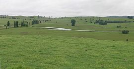
Northern Tablelands, New South Wales
|
Northern Tablelands New South Wales |
|||||||||||||
|---|---|---|---|---|---|---|---|---|---|---|---|---|---|

grazing country, Irish Town, Walcha.
|
|||||||||||||
|
|||||||||||||
The Northern Tablelands, also known as the New England Tableland, is a plateau and a region of the Great Dividing Range in northern New South Wales, Australia. It includes the New England Range, the narrow highlands area of the New England region, stretching from the Moonbi Range in the south to the Queensland border in the north. The region corresponds generally to the Bureau of Meteorology (Australia) forecast area for the Northern Tablelands which in this case includes Inverell although it is significantly lower in elevation.
These tablelands are the largest highland area in Australia, covering approximately 18,197 square kilometres. There are widespread high points over 1,000 metres including The Brothers (1,508m), Ben Lomond (1,505m), Mount Rumbee (1,503m), Point Lookout (1,564m), Campoompeta (1,510m), Mount Spirabo (1,492m), Mount Mitchell (1,475m), Chandler's Peak (1,471m), Mount Grundy (1,462m), Mount Bajimba (1,448 m) and the highest point at Round Mountain is 1,584 metres above sea level. The now closed railway station at Ben Lomond, was the highest railway station in Australia.
The formation of the Great Dividing Range has resulted in a wide variety of soil types being located on the Northern Tablelands. Here soils are mostly derived from basaltic rocks, granite rocks, trap rock or alluvials along creeks and rivers.
The eastern escarpment of the Tableland has spectacular gorges, rainforests and waterfalls, protected in more than 25 National Parks, with three of them listed as World Heritage Areas by UNESCO and forming part of the Central Eastern Rainforest Reserves (CERRA). Werrikimbe National Park and Oxley Wild Rivers National Park, one of the largest national parks in NSW are accessible from the Oxley Highway east of Walcha. The Oxley Wild Rivers National Park is also accessible via Waterfall Way east of Armidale and south of Hillgrove. Access to the World Heritage listed New England National Park is also from Waterfall Way.
...
Wikipedia
