Waterfall Way
|
Waterfall Way New South Wales |
|
|---|---|
 |
|
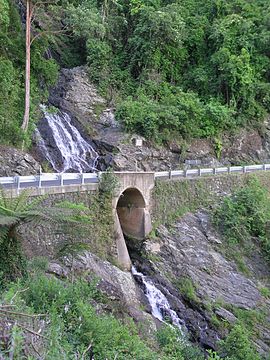
| Newell Falls, Waterfall Way, Dorrigo National Park | |
| Type | Highway |
| Length | 165 km (103 mi) |
| Route number(s) |
|
| Former route number |
|
| East end |
|
| West end |
|
| Major settlements | Bellingen, Dorrigo, Ebor |
|
Highways in Australia National Highway • Freeways in Australia Highways in New South Wales |
|
The Waterfall Way is a road in New South Wales, Australia. It runs east-west from the Pacific Highway to the New England Highway at Armidale. The route passes through some of New South Wales' most scenic countryside and has become well known as New South Wales best and Australia's third most beautiful tourist drive. Seven national parks, of which three are listed as World Heritage Areas by UNESCO and form part of the Gondwana Rainforests of Australia (formerly the Central Eastern Rainforest Reserves), are located on or close to the route. Dorrigo National Park encompasses the waterfalls that give the route its name. It also provides one of the few road links between coastal and inland New South Wales, and is therefore more heavily trafficked than its condition might otherwise suggest.
Starting from a junction with the Pacific Highway at Raleigh, midway between Urunga and Coffs Harbour, it follows the south bank of the Bellinger River, passing through Bellingen. After crossing the Bellinger River the road swings north and climbs the escarpment of the Great Dividing Range, skirting the southern edge of the Dorrigo world heritage rainforest and crossing the Newell and Sherrard waterfalls for which the route is named. Single lane traffic restrictions do not permit stopping at these falls, but the Newell Falls may be viewed at a rest area below the fall. At the top of the escarpment (elevation 750 m (2,460 ft)) a short detour south leads to Griffith's Lookout with views over the Bellinger River National Park and valley.
...
Wikipedia
