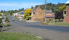
Walcha, New South Wales
|
Walcha New South Wales |
|||||||
|---|---|---|---|---|---|---|---|

Derby Street, Walcha
|
|||||||
| Coordinates | 30°59′S 151°36′E / 30.983°S 151.600°ECoordinates: 30°59′S 151°36′E / 30.983°S 151.600°E | ||||||
| Population | 1,482 (2011 census) | ||||||
| Established | 1852 | ||||||
| Postcode(s) | 2354 | ||||||
| Elevation | 1,067.0 m (3,501 ft) | ||||||
| Time zone | AEST (UTC+10) | ||||||
| • Summer (DST) | AEDT (UTC+11) | ||||||
| Location | 425 km (264 mi) from Sydney | ||||||
| LGA(s) | Walcha Shire | ||||||
| Region | Northern Tablelands | ||||||
| County | Vernon | ||||||
| Parish | Walcha | ||||||
| State electorate(s) | Tamworth | ||||||
| Federal Division(s) | New England | ||||||
|
|||||||
Walcha (/ˈwɒlkə/ WOL-kə) is a town at the south-eastern edge of the Northern Tablelands, New South Wales, Australia.
The town serves as the seat of Walcha Shire. Walcha is located 425 kilometres by road from Sydney at the intersection of the Oxley Highway and Thunderbolts Way. The Apsley River passes through the town to tumble over the Apsley Falls before joining the Macleay River further on. Originally the river caused flooding in the town prior to a levee bank being constructed and saving the town from more floods. At the 2011 census, Walcha had a population of 1,482 people.
The Main North railway line is located some distance away, at a separate village called Walcha Road which serves as the railhead. This is served by the daily NSW TrainLink Xplorer service between Sydney and Armidale. The railway line was built at Walcha Road, because it was the closest point they could get to the town, due to the steep climb over the Great Dividing Range.
...
Wikipedia

