Apsley River (New South Wales)
| Apsley River | |
| Perennial stream | |
|
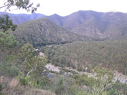
Apsley River in Oxley Wild Rivers National Park
|
|
| Name origin: In honour of The Lord Apsley, Secretary of State for Colonies | |
| Country | Australia |
|---|---|
| State | New South Wales |
| IBRA | New England Tablelands |
| District | Northern Tablelands |
| Local government area | Walcha |
| Part of | Macleay River catchment |
| Tributaries | |
| - left | Ohio Creek, Emu Creek (New South Wales), Rowleys Creek, Reedy Creek (New South Wales) |
| - right | Double Hut Creek, Tia River, Yarrowitch River |
| Town | Walcha |
| Source | Tia Range, Great Dividing Range |
| - location | west of Tia |
| - elevation | 1,260 m (4,134 ft) |
| Mouth | confluence with the Macleay River |
| - location | southwest the locality of Lower Creek |
| - elevation | 190 m (623 ft) |
| Length | 168 km (104 mi) |
| Waterfall | Apsley Falls |
| National park | Oxley Wild Rivers NP |
Apsley River, a perennial stream of the Macleay River catchment, is located in the Northern Tablelands district of New South Wales, Australia.
Apsley River rises in high country of the Tia Range, part of the Great Dividing Range, approximately 11 kilometres (6.8 mi) west of the locality of Tia and approximately 29 kilometres (18 mi) south of Walcha. The river flows generally north through the town of Walcha and on to make a dramatic spilling over the Apsley Falls, descending approximately 27 metres (89 ft) into the Apsley Gorge, towards its confluence with the Macleay River, approximately 24 kilometres (15 mi) southwest of the locality of Lower Creek. The Apsley River is joined by seven tributaries, including the Tia River and Yarrowitch River, as it makes its course, descending 1,070 metres (3,510 ft) over 168 kilometres (104 mi).
Together with the Macleay River, the Apsley River has developed deeply incised river valleys into Ordovician meta-sedimentary rocks including greywacke, slate, phyllite, schist, chert and argillites. This has produced a number of spectacular gorges and waterfalls on or near the Apsley River in the Oxley Wild Rivers National Park.
...
Wikipedia

