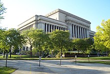
Milwaukee County, Wisconsin
| Milwaukee County, Wisconsin | |||
|---|---|---|---|

Milwaukee County Courthouse
|
|||
|
|||
 Location in the U.S. state of Wisconsin |
|||
 Wisconsin's location in the U.S. |
|||
| Founded | 1835 | ||
| Seat | Milwaukee | ||
| Largest city | Milwaukee | ||
| Area | |||
| • Total | 1,190 sq mi (3,082 km2) | ||
| • Land | 241 sq mi (624 km2) | ||
| • Water | 948 sq mi (2,455 km2), 80% | ||
| Population (est.) | |||
| • (2014) | 956,406 | ||
| • Density | 3,968/sq mi (1,532/km²) | ||
| Congressional districts | 1st, 4th, 5th, 6th | ||
| Time zone | Central: UTC-6/-5 | ||
| Website | county |
||
Milwaukee County is a county in the U.S. state of Wisconsin. As of the 2010 census, the population was 947,735 and was estimated to be 956,406 in 2014. It is the most populous county in Wisconsin and the 45th most populous in the United States. Its county seat is Milwaukee, which is also the most populous city in the state. The county was created in 1834 as part of Michigan Territory and organized the following year.
Milwaukee County is included in the Milwaukee-Waukesha-West Allis, WI Metropolitan Statistical Area as well as the Milwaukee-Racine-Waukesha, WI Combined Statistical Area.
Portions of what is now Milwaukee County are known to have been inhabited by a number of Native American tribes, including the Sauk, Meskwaki or "Fox", Menomonee, Ojibwe and Potawotami, with elements of other tribes attested as well.
In 1818, when the land later to be Wisconsin was made part of Michigan Territory, territorial governor Lewis Cass created Brown County, which at that time included all the land now part of Milwaukee County. It remained a part of Brown county until 1834, when Milwaukee County was created, including the area south of the line between townships eleven and twelve north (i.e., the northern boundary of Washington and Ozaukee counties), west of Lake Michigan, north of Illinois, and east of the line which now separates Green and Rock counties. This territory encompassed all of what are now Milwaukee, Jefferson, Kenosha, Ozaukee, Racine, Rock, Walworth, Washington, and Waukesha counties, as well as large parts of the present-day Columbia, Dane and Dodge counties.
...
Wikipedia


