Columbia County, Wisconsin
| Columbia County, Wisconsin | |
|---|---|

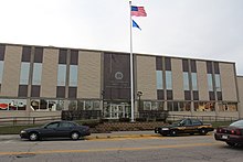
Columbia County courthouse in December 2014
|
|
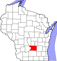
 Location in the U.S. state of Wisconsin |
|
 Wisconsin's location in the U.S. |
|
| Founded | 1846 |
| Seat | Portage |
| Largest city | Portage |
| Area | |
| • Total | 796 sq mi (2,062 km2) |
| • Land | 766 sq mi (1,984 km2) |
| • Water | 30 sq mi (78 km2), 3.8% |
| Population | |
| • (2010) | 56,833 |
| • Density | 74/sq mi (29/km²) |
| Congressional district | 6th |
| Time zone | Central: UTC-6/-5 |
| Website | www |
Columbia County is a county located in the U.S. state of Wisconsin. As of the 2010 census, the population was 56,833. Its county seat and largest city is Portage. The county was created in 1846. At the time, it was in the Wisconsin Territory.
Columbia County is part of the Madison, WI Metropolitan Statistical Area as well as the Madison-Janesville-Beloit, WI Combined Statistical Area.
According to the U.S. Census Bureau, the county has a total area of 796 square miles (2,060 km2), of which 766 square miles (1,980 km2) is land and 30 square miles (78 km2) (3.8%) is water. The county's highest point is Gibraltar Rock at 1,247 feet above sea level. The high butte-shaped bluff is located north of Lodi overlooking the Lake Wisconsin River valley.
As of the census of 2000, there were 52,468 people, 20,439 households, and 14,164 families residing in the county. The population density was 68 people per square mile (26/km²). There were 22,685 housing units at an average density of 29 per square mile (11/km²). The racial makeup of the county was 97.18% White, 0.88% Black or African American, 0.35% Native American, 0.33% Asian, 0.02% Pacific Islander, 0.44% from other races, and 0.79% from two or more races. 1.58% of the population were Hispanic or Latino of any race. 46.4% were of German, 10.2% Norwegian, 7.8% Irish, 6.4% English and 5.0% United States or American ancestry.
...
Wikipedia
