Dane County, Wisconsin
| Dane County, Wisconsin | ||
|---|---|---|

The Dane County Courthouse, 2004
|
||
|
||
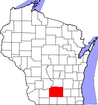
 Location in the U.S. state of Wisconsin |
||
 Wisconsin's location in the U.S. |
||
| Founded | 1839 | |
| Named for | Nathan Dane | |
| Seat | Madison | |
| Largest city | Madison | |
| Area | ||
| • Total | 1,238 sq mi (3,206 km2) | |
| • Land | 1,197 sq mi (3,100 km2) | |
| • Water | 41 sq mi (106 km2), 3.3% | |
| Population (est.) | ||
| • (2015) | 523,643 | |
| • Density | 431/sq mi (166/km²) | |
| Congressional district | 2nd | |
| Time zone | Central: UTC-6/-5 | |
| Website | www |
|
Dane County is a county in the U.S. state of Wisconsin. As of the 2010 census, the population was 488,073, making it the second-most populous county in Wisconsin. The 2015 estimate places the county's population at 523,643. The county seat is Madison, which is also the state capital.
Dane County is part of the Madison, Wisconsin, Metropolitan Statistical Area, as well as the Madison-Janesville-Beloit Combined Statistical Area.
Dane County was formed in 1836 as a territorial county and organized in 1839. It was named after Nathan Dane, a Massachusetts delegate to the Congress of the Confederation who helped carve Wisconsin out of the Northwest Territory. Dane County was first settled in the 1840s by settlers from New England.
According to the U.S. Census Bureau, the county has a total area of 1,238 square miles (3,210 km2), of which 1,197 square miles (3,100 km2) is land and 41 square miles (110 km2) (3.3%) is water.
As of the census of 2010, there were 488,073 people, 203,750 households, and 116,752 families residing in the county. The population density was 394 people per square mile (152/km²). There were 216,022 housing units at an average density of 174 per square mile (67/km²). The racial makeup of the county was 84.7% White, 5.2% Black or African American, 0.4% Native American, 4.7% Asian, 0.003% Pacific Islander, 2.5% from other races, and 2.5% from two or more races. 5.9% of the population were Hispanic or Latino of any race.
...
Wikipedia

