Mariposa County
| Mariposa County, California | |||||
|---|---|---|---|---|---|
| County | |||||
| Mariposa County | |||||
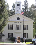
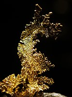
Images, from top down, left to right: The Mariposa County Courthouse; "The Dragon", crystalline gold from the Colorado Quartz Mine near Midpines; a view of Yosemite Valley from Tunnel View
|
|||||
|
|||||
 Location in the state of California |
|||||
 California's location in the United States |
|||||
| Country | |||||
| State |
|
||||
| Region | Sierra Nevada | ||||
| Incorporated | February 18, 1850 | ||||
| County seat | Mariposa | ||||
| Area | |||||
| • Total | 1,463 sq mi (3,790 km2) | ||||
| • Land | 1,449 sq mi (3,750 km2) | ||||
| • Water | 14 sq mi (40 km2) | ||||
| Population (April 1, 2010) | |||||
| • Total | 18,251 | ||||
| • Estimate (2015) | 17,531 | ||||
| • Density | 12/sq mi (4.8/km2) | ||||
| Time zone | Pacific Standard Time (UTC-8) | ||||
| • Summer (DST) | Pacific Daylight Time (UTC-7) | ||||
| Website | www.mariposacounty.org | ||||
Mariposa County is a county in the U.S. state of California. As of the 2010 census, the population was 18,251. The county seat is Mariposa. It is located in the western foothills of the Sierra Nevada mountains, north of Fresno, east of Merced, and southeast of .
The county's eastern section is the central portion of Yosemite National Park.
There are no incorporated cities in Mariposa County; however, there are communities recognized as census-designated places for statistical purposes. It also has the distinction of having no permanent traffic lights anywhere in the county.
Mariposa County was one of the original counties of California, created at the time of statehood in 1850. While it began as the state's largest county, territory that was once part of Mariposa was ceded over time to form twelve other counties: Fresno, Inyo, Kern, Kings, Los Angeles, Madera, Merced, Mono, San Benito, San Bernardino, San Luis Obispo, and Tulare. Thus, Mariposa County is known as the "Mother of Counties".
...
Wikipedia


