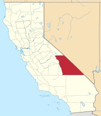
Inyo County, California
| County of Inyo | ||
|---|---|---|
| County | ||

Wildflowers blooming in Death Valley after an unusually wet winter
|
||
|
||
 Location in the state of California |
||
 California's location in the United States |
||
| Coordinates: 36°35′N 117°25′W / 36.583°N 117.417°WCoordinates: 36°35′N 117°25′W / 36.583°N 117.417°W | ||
| Country |
|
|
| State |
|
|
| Region | Eastern California | |
| Established | March 22, 1866 | |
| Named for | "dwelling place of the great spirit" in Mono language | |
| County seat | Independence | |
| Largest city | Bishop | |
| Government | ||
| • Board of Supervisors |
Supervisors
|
|
| • Assemblymember | Devon Mathis (R) | |
| • State senator | Tom Berryhill (R) | |
| • U. S. rep. | Paul Cook (R) | |
| Area | ||
| • Total | 10,227 sq mi (26,490 km2) | |
| • Land | 10,181 sq mi (26,370 km2) | |
| • Water | 46 sq mi (120 km2) | |
| Highest elevation | 14,505 ft (4,421 m) | |
| Lowest elevation | -279 ft (−85 m) | |
| Population (April 1, 2010) | ||
| • Total | 18,546 | |
| • Estimate (2015) | 18,260 | |
| • Density | 1.8/sq mi (0.70/km2) | |
| Time zone | Pacific Time Zone (UTC−8) | |
| • Summer (DST) | Pacific Daylight Time (UTC−7) | |
| Area codes | 442/760 | |
| FIPS code | 06-027 | |
| GNIS feature ID | 1804637 | |
| Website | www |
|
Inyo County is a county in the U.S. state of California. As of the 2010 census, the population was 18,546. The county seat is Independence.
Inyo County is on the east side of the Sierra Nevada and southeast of Yosemite National Park in Central California. It contains the Owens River Valley; it is flanked to the west by the Sierra Mountains and to the east by the White Mountains and the Inyo Mountains.
Mount Whitney, the highest peak in the Contiguous United States, is on Inyo County's western border (with Tulare County). The Badwater Basin in Death Valley National Park, the lowest place in North America, is in eastern Inyo County. The two points are not visible from each other, but both can be observed from the Panamint Range on the west side of Death Valley, above the Panamint Valley. It has the biggest elevation difference of all of the counties and county-equivalents in the contiguous United States.
With an area of 10,192 square miles (26,397 km2), Inyo County is the second-largest county by area in California, after San Bernardino County. Almost one-half of that area is within Death Valley National Park. However, with a population density of 1.8 people per square mile, it has the lowest population density of any county in California.
...
Wikipedia

