Independence, California
| Independence | |
|---|---|
| census-designated place | |

Independence town sign
|
|
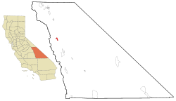
 Location in Inyo County and the state of California |
|
| Location in the United States | |
| Coordinates: 36°48′10″N 118°12′00″W / 36.80278°N 118.20000°WCoordinates: 36°48′10″N 118°12′00″W / 36.80278°N 118.20000°W | |
| Country |
|
| State |
|
| County | Inyo |
| Area | |
| • Total | 4.870 sq mi (12.612 km2) |
| • Land | 4.867 sq mi (12.605 km2) |
| • Water | 0.003 sq mi (0.007 km2) 0.057% |
| Elevation | 3,930 ft (1,198 m) |
| Population (2010) | |
| • Total | 669 |
| • Density | 140/sq mi (53/km2) |
| Time zone | Pacific (PST) (UTC-8) |
| • Summer (DST) | PDT (UTC-7) |
| ZIP code | 93526 |
| Area codes | 442/760 |
| FIPS code | 06-36350 |
| GNIS feature ID | 1658811 |
Independence is a census-designated place in Inyo County, California. Independence is located 41 miles (66 km) south-southeast of Bishop, at an elevation of 3930 feet (1198 m). It is the county seat of Inyo County, California. The population of this census-designated place was 669 at the 2010 census, up from 574 at the 2000 census.
The tiny village of Independence is bisected by U.S. Route 395, the main north-south highway through the Owens Valley.
The Sierra Nevada mountains to the west lie within the John Muir Wilderness Area. Onion Valley, one of the principal entry routes to the John Muir Wilderness, is accessed via the Onion Valley road which heads directly west out of Independence. This trail takes hikers to Kings Canyon/Sequoia National Parks which protect the Sierra Nevada west of the divide between the Owens Valley on the east and the rivers which drain into the San Joaquin Valley to the west.
Independence is a popular resupply location for hikers trekking the 2,650 mile long Pacific Crest Trail which extends from the Mexican border to Canada along the crest of the Sierra Nevada and Cascade Ranges. The highest pass along the entire trail, 13,153 foot (4009 m) Forester Pass, is directly west of Independence.
According to the United States Census Bureau, Independence covers an area of 4.9 square miles (13 km2), over 99% of it land.
The elevation of Independence is 3,925 feet (1,196 m) above sea level.
Independence, as well as most of the Owens Valley, has a high desert climate with hot summers and cold winters. January temperatures range from an average high of 54.0 °F to an average low of 27.4 °F. July temperatures range from an average high of 97.6 °F to an average low of 63.9 °F. The highest recorded temperature was 114 °F (46 °C) on July 7, 1989. The lowest recorded temperature was −5 °F (−21 °C) on January 9, 1937. There are an average of 97.7 days annually with highs of 90 °F (32 °C) or higher and an average of 88.1 days with lows of 32 °F (0 °C) or lower. Annual precipitation averages only 5.82 inches. The most precipitation in one month was 23.90 inches in February 1904. The most precipitation in 24 hours was 5.72 inches on December 6, 1966. Snowfall varies greatly from year to year, averaging only 5.2 inches. The most snow in one month was 112.0 inches in February 1904.
...
Wikipedia

