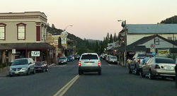
Mariposa, California
| Mariposa | |
|---|---|
| Census-designated place | |

Dusk in downtown Mariposa
|
|
 Location in Mariposa County and the state of California |
|
| Location in the United States | |
| Coordinates: 37°29′06″N 119°57′59″W / 37.48500°N 119.96639°WCoordinates: 37°29′06″N 119°57′59″W / 37.48500°N 119.96639°W | |
| Country |
|
| State |
|
| County | Mariposa |
| Area | |
| • Total | 12.880 sq mi (33.361 km2) |
| • Land | 12.850 sq mi (33.282 km2) |
| • Water | 0.030 sq mi (0.078 km2) 0.23% |
| Elevation | 1,949 ft (594 m) |
| Population (2010) | |
| • Total | 2,173 |
| • Density | 170/sq mi (65/km2) |
| Time zone | Pacific Time Zone (UTC-8) |
| • Summer (DST) | PDT (UTC-7) |
| ZIP code | 95338 |
| Area code | 209 |
| FIPS code | 06-45932 |
| GNIS feature IDs | 1659063, 2408181 |
Mariposa (formerly Aqua Fria) is a census-designated place (CDP) in and the county seat of Mariposa County, California, United States. The population was 2,173 at the 2010 census, up from 1,373 at the 2000 census. Its name is Spanish for "butterfly", after the flocks of monarchs seen there by early explorers.
Mariposa is located at 37°29′06″N 119°57′59″W / 37.48500°N 119.96639°W, at 1,949 feet (594 m) in elevation. It lies in the rugged foothills of the Sierra Nevada. Mariposa Creek flows through the town. Soils in the urban area are mostly brown to reddish brown loam of the Blasingame series. A gravelly loam is mapped as Boomer series. These soils support thick grassland plus trees such as blue oak, black oak, gray pine, and ponderosa pine. To the west-northwest of town is a large area of sparse vegetation and rockland on which is found serpentine soil of the Henneke series.
According to the United States Census Bureau, the CDP has a total area of 12.9 square miles (33 km2), all but 0.23% of it land.
...
Wikipedia

