Lower Rio Grande Valley
| Rio Grande Valley | |
| Region | |
| Country | |
|---|---|
| State | |
| Region | South Texas |
| Lowest point | |
| - location | Gulf of Mexico |
| - elevation | 0 m (0 ft) |
| Area | 12,619 km2 (4,872 sq mi) |
| Population | 1,336,323 (2014) |
| Density | 259/km2 (671/sq mi) |
| Timezone | Central (UTC-6) |
| Area code | 956 |
|
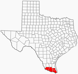
Map of the Rio Grande Valley
|
|
| Website: Handbook of Texas: Rio Grande Valley | |
The Rio Grande Valley (RGV), The Valley, is an area located in the southernmost tip of South Texas. It lies along the northern bank of the Rio Grande river, which separates Mexico from the United States. The four-county region, consisting of Hidalgo, Cameron, Willacy, and Starr counties, is one of the fastest growing places in the United States. From having about 325,000 people in 1969, to today a population over 1,300,000 in 2014. Some of the biggest cities in the region are; Brownsville, McAllen, Mission, Edinburg, Pharr, Weslaco, Harlingen, Rio Grande City, and Hidalgo.
The Rio Grande Valley is not a true valley, but a floodplain, containing many oxbow lakes or resacas formed from pinched-off meanders in earlier courses of the Rio Grande. Early 20th-century land developers, attempting to capitalize on unclaimed land, utilized the name "Magic Valley" to attract settlers and appeal to investors. The Rio Grande Valley is also called El Valle, the Spanish translation of "the valley", by those who live there. The residents of the Rio Grande Valley occasionally refer to the area as "El Mágico Valle del Río Grande" ("The Magical Valley of the Rio Grande"), and also simply by the initials R.G.V.
The main region is within four Texan counties: Starr County, Hidalgo County, Willacy County, and Cameron County. As of January 1, 2012, the U.S. Census Bureau estimated the population of the Rio Grande Valley at 1,305,782. According to the U.S. Census Bureau in 2008, 86 percent of Cameron County, 90 percent of Hidalgo County, 97 percent of Starr County, and 86 percent of Willacy County are Hispanic.
...
Wikipedia

