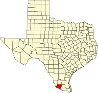
Starr County, Texas
| Starr County, Texas | |
|---|---|
| County | |
| Starr County | |
 Location in the U.S. state of Texas |
|
 Texas's location in the U.S. |
|
| Founded | 1848 |
| Named for | James Harper Starr |
| Government • Sheriff |
Rene "Orta" Fuentes |
| Seat | Rio Grande City |
| Largest city | Rio Grande City |
| Area | |
| • Total | 1,229 sq mi (3,183 km2) |
| • Land | 1,223 sq mi (3,168 km2) |
| • Water | 5.9 sq mi (15 km2), 0.5% |
| Population | |
| • (2010) | 60,968 |
| • Density | 50/sq mi (19/km²) |
| Congressional district | 28th |
| Time zone | Central: UTC-6/-5 |
| Website | www |
Starr County is a county located in the U.S. state of Texas. As of the 2010 census, its population was 60,968. Its county seat is Rio Grande City. The county was created in 1848. It is named for James Harper Starr, who served as Secretary of the Treasury of the Republic of Texas.
Starr County comprises the Rio Grande City, TX Micropolitan Statistical Area, which is also included in the McAllen-Edinburg, TX Combined Statistical Area. It is northeast from the Mexican border.
From 2000 to 2010 the population of Starr County increased from 53,597 to 60,968.
According to the U.S. Census Bureau, the county has a total area of 1,229 square miles (3,180 km2), of which 1,223 square miles (3,170 km2) is land and 5.9 square miles (15 km2) (0.5%) is water.
As of the 2010 United States Census, there were 60,968 people residing in the county. 0.4% were White, 0.2% Asian, 0.1% Native American, 0.1% Black or African American, 3.0% of some other race and 0.5% of two or more races. 95.7% were Hispanic or Latino (of any race). According to the Census Bureau, Starr County had the highest percentage of Hispanic residents of any county in the United States.
...
Wikipedia
