Lima, Ohio
| Lima, Ohio | ||
|---|---|---|
| City | ||

Public Square in downtown Lima
|
||
|
||
| Nickname(s): The Bean | ||
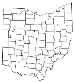
 Location in the state of Ohio |
||
 Location of Lima in Allen County |
||
| Coordinates: 40°44′27″N 84°6′54″W / 40.74083°N 84.11500°WCoordinates: 40°44′27″N 84°6′54″W / 40.74083°N 84.11500°W | ||
| Country | United States | |
| State | Ohio | |
| County | Allen | |
| Founded | 1831 | |
| Government | ||
| • Mayor | David Berger (D) | |
| Area | ||
| • Total | 13.80 sq mi (35.74 km2) | |
| • Land | 13.57 sq mi (35.15 km2) | |
| • Water | 0.23 sq mi (0.60 km2) | |
| Elevation | 879 ft (268 m) | |
| Population (2010) | ||
| • Total | 38,771 | |
| • Estimate (2015) | 37,873 | |
| • Density | 2,857.1/sq mi (1,103.1/km2) | |
| Time zone | EST (UTC−5) | |
| • Summer (DST) | EDT (UTC−4) | |
| Area code(s) | 419 567 | |
| FIPS code | 39-43554 | |
| GNIS feature ID | 1048916 | |
| Website | www.cityhall.lima.oh.us | |
Lima (/ˈlaɪmə/ LY-mə) is a city in and the county seat of Allen County, Ohio, United States. The municipality is located in northwestern Ohio along Interstate 75 approximately 72 miles (116 km) north of Dayton and 78 miles (126 km) south-southwest of Toledo.
As of the 2010 census, the city had a population of 38,771. It is the principal city of and is included in the Lima, Ohio Metropolitan Statistical Area, which is included in the Lima-Van Wert–Wapakoneta, Ohio, Combined Statistical Area. Lima was founded in 1831.
The Lima Army Tank Plant, built in 1941, is the sole producer of the M1 Abrams.
In the years after the American Revolution, the Shawnee were the most prominent residents of west central Ohio, growing in numbers and permanency after the 1794 Treaty of Greenville. By 1817, the United States had created the Hog Creek Reservation for the local Shawnee, covering portions of what would become Allen and Auglaize counties, and including part of present-day Lima.
...
Wikipedia

