Allen County, Ohio
| Allen County, Ohio | ||
|---|---|---|

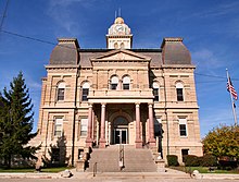
Allen County Courthouse in Lima
|
||
|
||
 Location in the U.S. state of Ohio |
||
 Ohio's location in the U.S. |
||
| Founded | March 1, 1831 | |
| Named for | John Allen | |
| Seat | Lima | |
| Largest city | Lima | |
| Area | ||
| • Total | 407 sq mi (1,054 km2) | |
| • Land | 402 sq mi (1,041 km2) | |
| • Water | 4.4 sq mi (11 km2), 1.1% | |
| Population | ||
| • (2010) | 106,331 | |
| • Density | 264/sq mi (102/km²) | |
| Congressional district | 4th | |
| Time zone | Eastern: UTC-5/-4 | |
| Website | www |
|
Allen County is a county in the U.S. state of Ohio. As of the 2010 census, the population was 106,331. The county seat is Lima. The county was created in 1820 and later organized in 1831. The county is named for Colonel John Allen, who was killed leading his men at the Battle of Frenchtown, during the War of 1812. It has also been claimed the county was named for Revolutionary War soldier Ethan Allen, but the weight of the evidence in favor of John Allen led the General Assembly to declare in 1976 that the county was named for him.
Allen County comprises the Lima, OH Metropolitan Statistical Area, which is also part of the Lima-Van Wert-Wapakoneta, OH Combined Statistical Area.
Under the terms of the Treaty of Greenville signed in 1795, northwestern Ohio was reserved for Native Americans. Thus the area now comprising Allen County was off-limits to European settlement until the Treaty of Maumee Rapids in 1817. Under the terms of this treaty, the Shawnee tribe was assigned reservations at Wapakonetta and at their "Hog Creek" settlement along the Ottawa River which comprised most of what is the present-day Shawnee Township. The latter treaty opened the way for the Ohio Legislature on March 1, 1820 to create fourteen counties, including Allen, which was defined as Ranges 5 through 8 east and Towns 3 through 6 south.
...
Wikipedia

