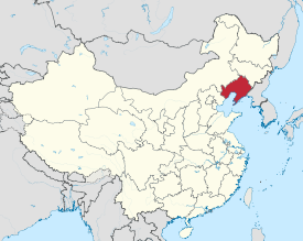
Liaoning province
|
Liaoning Province 辽宁省 |
|
|---|---|
| Province | |
| Name transcription(s) | |
| • Chinese | 辽宁省 (Liáoníng Shěng) |
| • Abbreviation | (pinyin: Liáo) |
 Map showing the location of Liaoning Province |
|
| Coordinates: 41°06′N 122°18′E / 41.1°N 122.3°ECoordinates: 41°06′N 122°18′E / 41.1°N 122.3°E | |
| Named for | The Liao River |
| Capital (and largest city) |
Shenyang |
| Divisions | 14 prefectures, 100 counties, 1511 townships |
| Government | |
| • Secretary | Li Xi |
| • Governor | Chen Qiufa |
| Area | |
| • Total | 145,900 km2 (56,300 sq mi) |
| Area rank | 21st |
| Population (2012) | |
| • Total | 43,900,000 |
| • Rank | 14th |
| • Density | 300/km2 (780/sq mi) |
| • Density rank | 15th |
| Demographics | |
| • Ethnic composition |
Han – 84% Manchu – 13% Mongol – 2% Hui - 0.6% Korean – 0.6% Xibe – 0.3% |
| • Languages and dialects | Northeastern Mandarin, Jiaoliao Mandarin, Beijing Mandarin, Pyongan Korean, Manchu |
| ISO 3166 code | CN-21 |
| GDP (2016) |
CNY 2.2 trillion 331 USD billion (7th) |
| • per capita |
CNY 50,287 USD 7,573 (7th) |
| HDI (2010) | 0.740 (high) (6th) |
| Website | www |
| Liaoning | |||||||||||||||

"Liaoning" in Simplified (top) and Traditional (bottom) Chinese characters
|
|||||||||||||||
| Chinese name | |||||||||||||||
|---|---|---|---|---|---|---|---|---|---|---|---|---|---|---|---|
| Simplified Chinese | |||||||||||||||
| Traditional Chinese | |||||||||||||||
| Postal | Liaoning | ||||||||||||||
| Literal meaning | "Pacified Liao" | ||||||||||||||
|
|||||||||||||||
| Manchu name | |||||||||||||||
| Manchu script | ᠯᡳᠶᠣᠣ ᠨᡳᠩ | ||||||||||||||
| Romanization | Liyoo-ning | ||||||||||||||
| Transcriptions | |
|---|---|
| Standard Mandarin | |
| Hanyu Pinyin | Liáoníng |
| Bopomofo | ㄌㄧㄠˊ ㄋㄧㄥˊ |
| Gwoyeu Romatzyh | Liauning |
| Wade–Giles | Liao2-ning2 |
| IPA | [li̯ǎu̯nǐŋ] |
| Fengtian | |||||||||||||
| Chinese name | |||||||||||||
|---|---|---|---|---|---|---|---|---|---|---|---|---|---|
| Chinese | |||||||||||||
| Postal | Fengtien | ||||||||||||
|
|||||||||||||
| Manchu name | |||||||||||||
| Manchu script | ᠠᠪᡴᠠᡳ ᡳᠮᡳᠶᠠᠩᡤᠠ | ||||||||||||
| Romanization | Abkai-imiyangga | ||||||||||||
| Transcriptions | |
|---|---|
| Standard Mandarin | |
| Hanyu Pinyin | Fèngtiān |
| Bopomofo | ㄈㄥˋ ㄊㄧㄢ |
| Gwoyeu Romatzyh | Fenqtian |
| Wade–Giles | Fêng4-tʻien1 |
Liaoning (Chinese: 辽宁; pinyin: ![]() Liáoníng ) is a province of China, located in the northeast of the country. The modern province was established in 1907 as Fengtian or Fengtien province and the name was changed to Liaoning in 1929. It was also known as Mukden province at the time, for the Manchu pronunciation of Shengjing, the former name of the provincial capital Shenyang. Under the Japanese-puppet Manchukuo regime, the province reverted to its 1907 name but the name Liaoning was restored in 1945 and again in 1954.
Liáoníng ) is a province of China, located in the northeast of the country. The modern province was established in 1907 as Fengtian or Fengtien province and the name was changed to Liaoning in 1929. It was also known as Mukden province at the time, for the Manchu pronunciation of Shengjing, the former name of the provincial capital Shenyang. Under the Japanese-puppet Manchukuo regime, the province reverted to its 1907 name but the name Liaoning was restored in 1945 and again in 1954.
Liaoning is the southernmost part of Manchuria, the Chinese Northeast. It is also known in Chinese as "the Golden Triangle" from its shape and strategic location, with the Yellow Sea (Korea Bay and Bohai Sea) in the south, North Korea's North Pyongan and Chagang provinces in the southeast, Jilin to the northeast, Hebei to the southwest, and Inner Mongolia to the northwest. The Yalu River marks its border with North Korea, emptying into the Korea Bay between Dandong in Liaoning and Sinuiju in North Korea.
...
Wikipedia
