Kings—Hants
|
|
|||
|---|---|---|---|

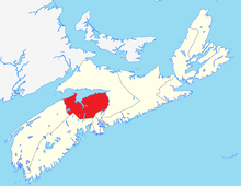
Kings—Hants in relation to the other Nova Scotia federal electoral districts (2003 boundaries)
|
|||
| Federal electoral district | |||
| Legislature | House of Commons | ||
| MP |
Liberal |
||
| District created | 1966 | ||
| First contested | 1968 | ||
| Last contested | 2015 | ||
| District webpage | profile, map | ||
| Demographics | |||
| Population (2016) | 83,465 | ||
| Electors (2015) | 66,454 | ||
| Area (km²) | 4,124 | ||
| Pop. density (per km²) | 20.2 | ||
| Census divisions | Hants, Kings | ||
| Census subdivisions | Cambridge 32, East Hants, Glooscap 35, Hantsport, Indian Brook 14, Kentville, Kings, Subd. A, Kings, Subd. B, Kings, Subd. C, Kings, Subd. D, West Hants, Windsor, Wolfville | ||
Kings—Hants (formerly Annapolis Valley—Hants and Annapolis Valley) is a federal electoral district in Nova Scotia, Canada, that has been represented in the Canadian House of Commons since 1968.
It is a largely rural and fairly conservative riding, but its conservatism is in the Red Tory tradition of the rest of the Maritimes, i.e., there is a strong concern for social programs.
Ethnic groups: 93.8% White, 3.6% Aboriginal, 1.3% Black
Languages: 96.2% English, 1.4% French
Religions: 71.7% Christian (17.4% Baptist, 17.1% Catholic, 15.3% United Church, 12.5% Anglican, 1.7% Presbyterian, 1.5% Pentecostal, 6.1% Other), 27.4% No religion
Median income (2010): $27,133
Average income (2010): $33,726
The district includes all of Hants County and the eastern part of Kings County. Communities include Enfield, Elmsdale, Lantz, Kentville, Windsor and Wolfville.
The electoral district was created as "Annapolis Valley in 1966 from parts of Colchester—Hants and Digby—Annapolis—Kings ridings.
In 1996, it was renamed "Kings—Hants". In 2003, it was given its current boundaries: the area encompassed by the provincial electoral district of Kings West was removed from Kings—Hants and added to West Nova. There will be no territory changes as a result of the 2012 federal electoral redistribution.
...
Wikipedia
