Kandahar Province, Afghanistan
|
Kandahar Pashto: کندهار ولايت Persian: ولایت قندهار |
|
|---|---|
| Province | |

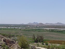
View of Arghandab River Valley
|
|
| Nickname(s): Loy kandahar | |
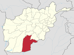
 Map of Afghanistan with Kandahar highlighted |
|
| Coordinates (Capital): 31°00′N 65°30′E / 31.0°N 65.5°ECoordinates: 31°00′N 65°30′E / 31.0°N 65.5°E | |
| Country |
|
| Capital | Kandahar |
| Government | |
| • Governor | Zalmay Wesa |
| Area | |
| • Total | 54,022 km2 (20,858 sq mi) |
| Population (2012) | |
| • Total | 1,151,100 |
| • Density | 21/km2 (55/sq mi) |
| Time zone | UTC+4:30 |
| Area code(s) | AF-KAN |
| Main languages | Pashto |
Kandahar (Pashto: کندھار; Persian: قندهار) is one of the thirty-four provinces of Afghanistan, located in the southern part of the country next to Pakistan. It is surrounded by Helmand in the west, Uruzgan in the north and Zabul Province in the east. Its capital is the city of Kandahar, which is located on the Arghandab River. The greater region surrounding the province is called Loy Kandahar.
The province contains about 18 districts, over 1,000 villages, and approximately 1,151,100 people, which is mostly tribal and a rural society. The main inhabitants of Kandahar province are the native ethnic Pashtuns, although smaller communities of Tajiks, Hazaras, Uzbeks and Baloch are also found in parts of the city of Kandahar. The current governor of the province is Humayoon Azizi.
There is speculation about the origin of the name "Kandahar". It is believed to have started as one of many cities named after the Hellenistic conqueror Alexander the Great throughout his vast (mainly ex-Achaemenid) empire, its present form deriving from the Pashto rendering of Arabic Iskandariya = Ancient Alexandria (in Arachosia).
...
Wikipedia
