Indus River Valley
| Indus (دریائے سندھ) | |
| River | |
|
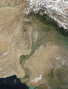
Satellite image of the Indus River basin in Pakistan and India
|
|
| Countries |
|
|---|---|
| State | Gilgit-Baltistan, Jammu and Kashmir Khyber Pakhtunkhwa, Punjab, Sindh Tibet |
| Tributaries | |
| - left | Zanskar River, Suru River, Soan River, Jhelum River, Chenab River, Ravi River, Beas River, Sutlej River, Panjnad River |
| - right | Shyok River, Hunza River, Gilgit River, Swat River, Kunar River, Kabul River, Kurram River, Gomal River, Zhob River |
| Cities | Leh, Skardu, Dasu, Besham, Thakot, Dera Ismail Khan, Sukkur, Hyderabad |
| Primary source | Sênggê Zangbo |
| - location | Tibetan Plateau |
| Secondary source | Gar Tsangpo |
| Source confluence | |
| - location | Shiquanhe, Ngari Prefecture, China |
| - elevation | 4,255 m (13,960 ft) |
| - coordinates | 32°29′54″N 79°41′28″E / 32.49833°N 79.69111°E |
| Mouth | Arabian Sea (primary), Rann of Kutch (secondary) |
| - location | Indus River Delta (primary), Thar Desert (secondary), Pakistan |
| - elevation | 0 m (0 ft) |
| - coordinates | 23°59′40″N 67°25′51″E / 23.99444°N 67.43083°ECoordinates: 23°59′40″N 67°25′51″E / 23.99444°N 67.43083°E |
| Length | 3,610 km (2,243 mi) |
| Basin | 1,165,000 km2 (449,809 sq mi) |
| Discharge | for Arabian Sea |
| - average | 6,600 m3/s (233,077 cu ft/s) |
| - max | 58,000 m3/s (2,048,251 cu ft/s) |
| - min | 1,200 m3/s (42,378 cu ft/s) |
|
Map of the Indus River basin
|
|
The Indus River (Urdu: دریائے سندھ; Hindi:सिंधु; Chinese: 印度河) also called Sindhū or Abāsīn, is a major south-flowing river in South Asia. The total length of the river is 3,610 km (1,988mi) which makes it one of the longest rivers in Asia. Originating in the western part of Tibet in the vicinity of Mount Kailash and Lake Manasarovar, the river runs a course through Ladakh, Gilgit-Baltistan, and Khyber Pakhtunkhwa, and then flows along the entire length of Punjab to merge into the Arabian Sea near the city of Thatta in Sindh. It is the longest river and national river of Pakistan.
The river has a total drainage area exceeding 1,165,000 km2 (450,000 sq mi). Its estimated annual flow stands at around 243 km3 (58 cu mi), twice that of the Nile River and three times that of the Tigris and Euphrates rivers combined, making it the twenty-first largest river in the world in terms of annual flow. The Zanskar is its left bank tributary in Ladakh. In the plains, its left bank tributary is the Chenab which itself has four major tributaries, namely, the Jhelum, the Ravi, the Beas, and the Sutlej. Its principal right bank tributaries are the Shyok, the Gilgit, the Kabul, the Gomal, and the Kurram. Beginning in a mountain spring and fed with glaciers and rivers in the Himalayas, the river supports ecosystems of temperate forests, plains and arid countryside.
...
Wikipedia


