Leh
|
Leh གླེ་ |
|
|---|---|
| City | |

|
|
| Coordinates: 34°08′43.43″N 77°34′03.41″E / 34.1453972°N 77.5676139°ECoordinates: 34°08′43.43″N 77°34′03.41″E / 34.1453972°N 77.5676139°E | |
| Country | India |
| State | Jammu and Kashmir |
| District | Leh |
| Deputy Commissioner | Saugat Biswas, IAS |
| Area | |
| • Total | 45,110 km2 (17,420 sq mi) |
| Elevation | 3,500 m (11,500 ft) |
| Population (2011) | |
| • Total | 30,870 |
| • Density | 0.68/km2 (1.8/sq mi) |
| Languages | |
| • Official |
Organised alphabetically: |
| Time zone | IST (UTC+5:30) |
| Website | www |
Organised alphabetically:
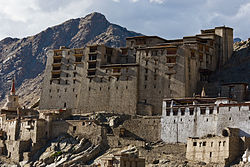
Leh ![]() i/leɪ/ (Tibetan alphabet: གླེ་, Wylie: Gle), was the capital of the Himalayan kingdom of Ladakh, now the Leh district in the Indian state of Jammu and Kashmir. Leh district, with an area of 45,110 km2, is the second largest district in the country, after Kutch, Gujarat (in terms of area). The town is dominated by the ruined Leh Palace, the former mansion of the royal family of Ladakh, built in the same style and about the same time as the Potala Palace-the chief residence of the Dalai Lama until the 14th Dalai Lama fled to Dharamsala, India, during the 1959 Tibetan uprising. Leh is at an altitude of 3,524 metres (11,562 ft), and is connected via National Highway 1D to Srinagar in the southwest and to Manali in the south via the Leh-Manali Highway. In 2010, Leh was heavily damaged by the sudden floods caused by a cloud burst.
i/leɪ/ (Tibetan alphabet: གླེ་, Wylie: Gle), was the capital of the Himalayan kingdom of Ladakh, now the Leh district in the Indian state of Jammu and Kashmir. Leh district, with an area of 45,110 km2, is the second largest district in the country, after Kutch, Gujarat (in terms of area). The town is dominated by the ruined Leh Palace, the former mansion of the royal family of Ladakh, built in the same style and about the same time as the Potala Palace-the chief residence of the Dalai Lama until the 14th Dalai Lama fled to Dharamsala, India, during the 1959 Tibetan uprising. Leh is at an altitude of 3,524 metres (11,562 ft), and is connected via National Highway 1D to Srinagar in the southwest and to Manali in the south via the Leh-Manali Highway. In 2010, Leh was heavily damaged by the sudden floods caused by a cloud burst.
...
Wikipedia


