Jammu and Kashmir
|
Jammu and Kashmir جموں و کشمیر |
|||
|---|---|---|---|
| State | |||
|
|||
 Location of Jammu and Kashmir in India |
|||
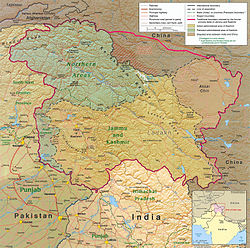
 Map of Jammu and Kashmir |
|||
| Coordinates (Srinagar): 33°27′N 76°14′E / 33.45°N 76.24°ECoordinates: 33°27′N 76°14′E / 33.45°N 76.24°E | |||
| Country |
|
||
| Admission to Union | 26 October 1947 | ||
| Capital | |||
| Largest city | Srinagar | ||
| Districts | 22 | ||
| Government | |||
| • Governor | Narinder Nath Vohra | ||
| • Chief Minister | Mehbooba Mufti (JKPDP) | ||
| • Deputy Chief Minister | Nirmal Kumar Singh (BJP) | ||
| • Legislature | Bicameral (87 + 36 seats) | ||
| • Parliamentary constituency |
Rajya Sabha 4 Lok Sabha 6 |
||
| Area | |||
| • Total | 222,236 km2 (85,806 sq mi) | ||
| Area rank | 14th | ||
| Population (2011) | |||
| • Total | 12,541,302 | ||
| • Rank | 19th | ||
| • Density | 56/km2 (150/sq mi) | ||
| Time zone | IST (UTC+05:30) | ||
| ISO 3166 code | IN-JK | ||
| HDI |
|
||
| HDI rank | 17th (2005) | ||
| Literacy | 66.7% (21st) | ||
| Official language(s) | Urdu | ||
| Other spoken | Kashmiri, Dogri, Hindi, Punjabi, Ladakhi | ||
| Website | jk |
||
| Bird | Black-necked crane |
|---|---|
| Flower | Lotus |
| Tree | Chinar tree |
| Population increase | |||
|---|---|---|---|
| Census | Pop. | %± | |
| 1951 | 3,254,000 |
—
|
|
| 1961 | 3,561,000 | 9.4% | |
| 1971 | 4,617,000 | 29.7% | |
| 1981 | 5,987,000 | 29.7% | |
| 1991 | 7,837,000 | 30.9% | |
| 2001 | 10,143,700 | 29.4% | |
| 2011 | 12,548,926 | 23.7% | |
| Source:Census of India The 1991 Census could not be held in Jammu and Kashmir, the 1991 population is interpolated. |
|||
Jammu and Kashmir (![]() i/ˈdʒæmuː ənd ˌkæʃˈmɪər, ˈdʒʌ-, ˈkæʃmɪər/) is a state in northern India, often denoted by the acronym J&K. It is located mostly in the Himalayan mountains, and shares borders with the states of Himachal Pradesh and Punjab to the south. Jammu and Kashmir has an international border with China in the north and east, and the Line of Control separates it from the Pakistani-administered territories of Azad Kashmir and Gilgit-Baltistan in the west and northwest respectively. The state has special autonomy under Article 370 of the Constitution of India.
i/ˈdʒæmuː ənd ˌkæʃˈmɪər, ˈdʒʌ-, ˈkæʃmɪər/) is a state in northern India, often denoted by the acronym J&K. It is located mostly in the Himalayan mountains, and shares borders with the states of Himachal Pradesh and Punjab to the south. Jammu and Kashmir has an international border with China in the north and east, and the Line of Control separates it from the Pakistani-administered territories of Azad Kashmir and Gilgit-Baltistan in the west and northwest respectively. The state has special autonomy under Article 370 of the Constitution of India.
...
Wikipedia


