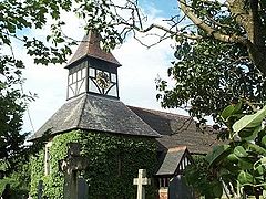
Harlaston
| Harlaston | |
|---|---|
 St Matthew's Church |
|
| Harlaston shown within Staffordshire | |
| Population | 394 (2011) |
| OS grid reference | SK215109 |
| Civil parish |
|
| District | |
| Shire county | |
| Region | |
| Country | England |
| Sovereign state | United Kingdom |
| Post town | TAMWORTH |
| Postcode district | B79 |
| Dialling code | 01827 |
| Police | Staffordshire |
| Fire | Staffordshire |
| Ambulance | West Midlands |
| EU Parliament | West Midlands |
| UK Parliament | |
| Website | www.harlaston.org.uk |
Harlaston is a village and civil parish in Staffordshire, England. It lies on the River Mease, about 5 miles (8 km) north of Tamworth. There is an Early English church, dedicated to St Matthew, and a public house, the White Lion.
Harlaston is a conservation area, and has won the Staffordshire Best Kept Small Village award 5 times.
The name Harlaston comes from Old English, and means either Heoruwulf's farm or Heorulaf's farm. It has been suggested that the church goes back to the 11th century and is of Anglo-Saxon origin. Certainly, a corn mill is mentioned in the Domesday Book.
Until 1845 Harlaston was a chapelry of the parish of Clifton Campville, after which date it became an independent ecclesiastical parish.
In 1851 the population was 221, on about 1400 acres of land. There were 2 lords of the manor, Captain Theophilus Levett and W Chettle, though much of the land belonged to other people.
The township of Harlaston became part of Tamworth Poor Law Union in 1836. In 1866 it also became a civil parish in its own right, becoming part of Tamworth Rural District in 1894. During the boundary changes of 1934, the parish was extended to incorporate Haselour, becoming part of Lichfield Rural District. In 1974 it became part of the new non-metropolitan district of Lichfield.
...
Wikipedia

