Clifton Campville
| Clifton Campville | |
|---|---|
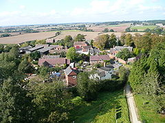
 Clifton Campville from above |
|
| Clifton Campville shown within Staffordshire | |
| Population | 912 (2011) |
| OS grid reference | SK255110 |
| Civil parish |
|
| District | |
| Shire county | |
| Region | |
| Country | England |
| Sovereign state | United Kingdom |
| Post town | TAMWORTH |
| Postcode district | B79 0 |
| Dialling code | 01827 |
| Police | Staffordshire |
| Fire | Staffordshire |
| Ambulance | West Midlands |
| EU Parliament | West Midlands |
| UK Parliament | |
Clifton Campville is a village and civil parish in Staffordshire, England. It lies on the River Mease, about 10 miles (16 km) east of the City of Lichfield, 6 miles (10 km) west of Measham and 7 miles (11 km) north of Tamworth. The village lies very close to Stafforshire's borders with Derbyshire, Leicestershire and Warwickshire. In 2001 the parish had a population of 764, increasing to 912 at the 2011 census.
There is a fine gothic church, dedicated to St Andrew, and listed Grade I. The village pub, The Green Man, is also a historic building.
The first part of the name is Old English clif tun, that is cliff farm; the family de Camvill held the land in the early 13th century. The name has also been recorded as Clistone.
There is some evidence of pre-Saxon, or even pre-historic settlement in the area. The settlement of Clistone is mentioned in Domesday Book as having 33 villagers, a priest, 11 ploughs and 2 mills. One of the mills was possibly at Mill Farm.
After the Norman Conquest the manor belonged to the king. From 1200 it was owned by the Camville (or de Camvill) family, at least until 1315. By 1700 it was in possession of the Coventry family, who sold it in that year to Sir Charles Pye, Bart. His family still owned the manor in 1851, in the person of Henry John Pye.
In 1848 the parish included both Haunton and Harlaston, and also Chilcote in Derbyshire. Clifton itself then had a population of 341, while the population of the whole parish was 921 on 6,300 acres (25 km2). The core parish of Clifton and Haunton covered around 3,000 acres (12 km2) in 1851. Nowadays the Church of England parish still includes Haunton and Chilcote, and also Statfold.
...
Wikipedia

