Drang-drung
| Drang-Drung Glacier | |
|---|---|

Drang-Drung Glacier
|
|
| Type | Mountain glacier |
| Location | Himalaya Range, Zanskar Range, Pensi La, Jammu and Kashmir |
| Coordinates | 33°45′18.77″N 76°18′3.47″E / 33.7552139°N 76.3009639°ECoordinates: 33°45′18.77″N 76°18′3.47″E / 33.7552139°N 76.3009639°E |
| Length | 23 kilometres (14 mi) |
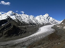
The Drang-Drung Glacier (also called Durung Drung Glacier) is a mountain glacier near the Pensi La mountain pass at the Kargil - Zanaskar Road in the Kargil district of Jammu and Kashmir in India.
The Drang-Drung Glacier is likely to be the largest glacier in Ladakh other than the Siachen Glacier in the Karakoram Range, with a maximum length of 23 kilometres (14 mi) at an average elevation of 4,780 m (15,680 feet). The glacier lies in the northeastern Himalayan Range known as the Zanskar Range, 142 kilometres (88 mi) south of Kargil and 331 kilometres (206 mi) east of Srinagar, the capital of Jammu and Kashmir.
The Drang-Drung Glacier is a long river of ice and snow, a source of the Stod River which is a tributary of the Zanskar River and the Zanskar River is a tributary of Indus River. Doda Peak with an elevation of 6,550 m (21,490 feet) rises from the glacier.
The Drang-Drung Glacier is accessible from Srinagar or Srinagar Airport in two days, 331 kilometres (206 mi) by car or bus which leads by NH 1D, a national highway which connects Srinagar and Leh through the towns of Ganderbal, Kangan, Sonamarg, and Dras. Kargil town is at the half-way point. From Kargil the glacier lies on the right side of Kargil-Zanaskar Road which passes through a gorge valley of Suru River and under the shades of two mountain peaks of Nun and Kun. After crossing the Pensi La mountain pass a trek of one day from the road leads to the head of Drang-Drung Glacier. The road is only open to traffic from May–September due to heavy snowfall at Zojila and Pensi La passes, and the best time to visit is July to August.
...
Wikipedia
