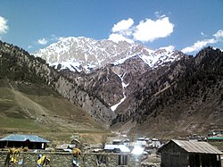
Sonamarg
|
Sonamarg The Meadow of Gold |
|
|---|---|
| hill station | |

Sonamarg towards north
|
|
| Location in Jammu and Kashmir, Republic of India | |
| Coordinates: 34°20′N 75°20′E / 34.33°N 75.33°ECoordinates: 34°20′N 75°20′E / 34.33°N 75.33°E | |
| Country |
|
| State | Jammu and Kashmir |
| District | Ganderbal |
| Elevation | 2,800 m (9,200 ft) |
| Population | |
| • Total | 392 |
| Languages | |
| • Official | Urdu |
| Time zone | IST (UTC+5:30) |
| PIN | 191202 |
| Telephone code | +91-1942417- |
| Vehicle registration | JK16 |
Sonamarg (translation: "Meadow of Gold") is a hill station in Ganderbal district in the Indian state of Jammu and Kashmir.
Sonamarg gives rise to The Three Sisters (Kashmir). In its vicinity lies the great Himalayan glaciers of Kashmir Valley namely Kolhoi Glacier and Machoi Glacier with some peaks of above 5000 meters: Sirbal Peak, Kolhoi Peak, Amarnath Peak and Machoi Peak. Sonamarg an alpine valley is situated at the bank of Nallah Sindh, 87 km north-east from Srinagar, it is a popular tourist destination, nestled with in the imposing Himalayan peaks. It lies at an altitude of 2800 metres above sea level. The drive to Sonamarg is through yet another spectacular facet of country side in Kashmir, this time it is the Nallah Sindh, the largest tributary of the Jehlum River in the valley of Kashmir. It is upwards of sixty miles long valley and deep rock-girt gorge to open grassy meadow land and village-dotted slopes.
Sonamarg has no permanent settlement and is inaccessible during winter due to heavy snowfall and avalanches. At the 2011 India census, Sonamarg had a population of 392, excluding tourists and those working in the tourism industry. Males constitute 51% and females constitute 49%. These are the permanent residents of Sonamarg though seasonally.
Sonamarg had historical significance and was a gateway on ancient Silk Road along with Gilgit connecting Kashmir with China and other Gulf countries. The Zojila pass lies 15 kilometers east and is one of the highest passes for road transport. It still is a base camp for Ladakh on NH 1D, and is strategically important for Indian army who holds control over this part of Kashmir.
...
Wikipedia


