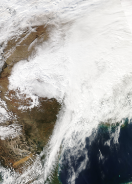
December 2013 North American ice storm

Satellite image from NASA depicting the system over the Central United States on December 21.
|
|
| Type |
Ice storm Winter storm Extratropical cyclone Tornado outbreak |
|---|---|
| Formed | December 19, 2013 |
| Dissipated | December 23, 2013 |
| Lowest pressure | 997 mb (29.44 inHg) |
| Tornadoes confirmed | 15 |
| Maximum snowfall or ice accretion | Snowfall – ~14 in (36 cm) Ice – Around 30 mm (1.2 in) |
| Damage | $54 million – $200 million (2013 USD) |
| Power outages | 1,500,000 |
| Areas affected | Southern Ontario, Southern Quebec, Upper Midwest, Great Plains, Southeastern United States, East Coast, Michigan, northern New England, Nova Scotia, Canada, Newfoundland, |
| Part of the 2013–14 North American winter and tornado outbreaks of 2013 | |
The December 2013 North American storm complex was a significant storm complex that had all sorts of severe weather, including a winter storm, a crippling ice storm and a tornado outbreak that impacted the central and eastern portions of Canada, parts of the Central Great Plains, the Southern United States, and the northeastern United States from December 20 to 23, 2013. Formed in the South Central United States, the storm headed across the Great Plains towards Canada into Atlantic Canada and northeastern United States where the storm dissipated on December 23, 2013. The storm produced freezing rain and snow to the affected areas which caused massive damage to electric power transmission and trees. The storm resulted in 27 deaths, loss of power to over a million of residents and over $200 million in damages. The storm produced similar conditions to the ice storm of 1998 which affected similar areas.
On December 19, an area of low pressure that had formed over Texas traveled through the northwestern part of Arkansas, passing through Oklahoma overnight on December 19, heading towards the Midwestern United States and the Great Plains where lower temperatures forecast ice accumulation. It entered Ontario, Canada, by 2:00 pm on December 20, when a freezing rain warning was in place. The associated warm front, which ran from Texas, met a cold air mass in eastern Canada, where large amounts of snow fell. Near the front, precipitation was in the form of freezing rain and ice pellets. The front gradually extended toward Atlantic Canada during the night of December 20–21, affecting extreme Southern Quebec and later the Maritimes. By mid-day on December 21, an upper-level low had developed in central Texas, and this began to draw moisture from the Gulf of Mexico. While moving to the northeast, the storm dumped heavy snow and ice over parts of the Upper Midwest and Michigan Peninsula through December 21. One specific part of the storm close to the upper-level low lingered near Kansas and cranked out snowfall rates of 1–2 inches (2.5–5.1 cm) per hour, before eventually moving northwards and leaving behind snowfall totals of up to 10–14 inches (25–36 cm) in some areas.
...
Wikipedia
