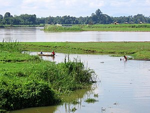
Daying River
| Taping Ta Hkaw Hka / Daying |
|
|---|---|

|
|
| Country | Burma |
| Physical characteristics | |
| Main source | China |
| River mouth |
Ayeyarwady River 103 m (338 ft) 24°17′35″N 97°13′12″E / 24.29306°N 97.22000°ECoordinates: 24°17′35″N 97°13′12″E / 24.29306°N 97.22000°E |
The Taping River, known as Ta Hkaw Hka in Kachin and Daying River (Chinese: 大盈江; pinyin: Dàyíng Jiāng; Wade–Giles: Ta-ying Chiang) in Chinese, is a river in Yunnan province, China and northern Myanmar (Burma). It is the first tributary of the country's chief river, the Irrawaddy, and the watersheds between it and the N'mai Hka river to the northwest and the rivers Shweli and Salween to the southeast form part of the boundary between China and Myanmar. Its source lies in Yingjiang County of Yunnan, and it enters the Irrawaddy near Bhamo, Kachin State.
In 1277 King Narathihapate of Bagan had an ambassador from Kublai Khan executed and then invaded the state of Kanngai along the Taping river, 70 miles north of Bhamo, for submitting to the Mongols. The Chinese defeated the Burmese in the Battle of Ngasaunggyan, a vivid account of which was reported back to Europe later by Marco Polo. The Chinese army advanced to Kaungsin but turned back because of excessive heat. They returned however in 1283, destroying Kaungsin and advancing into the Irrawaddy valley culminating in the fall of Bagan.
Trade with China had taken place along the Taping river for centuries through Kaungsin until Bhamo became more important from the 15th Century onwards.
During the Second World War the Allies built the Ledo Road from India to China across northern Burma, and before Christmas 1944, completed 354 miles to reach Myothit on the Taping river in order to link up with the old Burma Road at Bhamo.American GIs in the road gang had pleasant recollections of their time along the river trading with locals for souvenirs and hunting in the jungle. Pontoon bridges were built by engineers across 10 major rivers including the Taping.
...
Wikipedia
