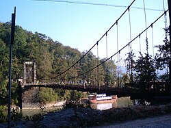
Shweli River
| Shweli River | |
|---|---|

Bridge over River Shweli
|
|
 |
|
| Native name | Nam Mao / 瑞丽江 |
| Country | Myanmar, China |
| Basin features | |
| Main source | Shan Hills |
| River mouth |
Ayeyarwady River by Inywa 89 m (292 ft) 23°56′49″N 96°17′0″E / 23.94694°N 96.28333°ECoordinates: 23°56′49″N 96°17′0″E / 23.94694°N 96.28333°E |
Shweli River (Burmese: ရွှေလီမြစ်) is a river in Myanmar (Burma). Also known as Nam Mao in Shan and Lung Chuan Chiang in Chinese, it forms part of the boundary between Burma and China. It is one of the tributaries of the country's chief river, the Ayeyarwady, and arises in Yunnan Province of China. It flows through northern Shan state and Sagaing Division, and enters the Ayeyarwady at Inywa, 60 km north of Tagaung and south of Katha.
Tai people, known as Shan in Burma, migrated from Yunnan into Burma along the Shweli. Maw Shans from Mong Mao settled in the Shweli valley, and raided and invaded the Bamar heartlands down the Shweli, but King Anawrahta of Bagan (1044–1077) reduced them to a vassal state. The fall of the kingdom of Bagan in the 13th century, however, saw a resurgence of Shan power, although King Bayinnaung (1551–1581) of the Taungoo Dynasty succeeded in pacifying them to establish Burmese suzerainty once and for all. King Hsinbyushin (1763–1776) of the Konbaung Dynasty also successfully repelled Chinese invasions (1765-9) that advanced down the Shweli and Myitnge river valleys.
...
Wikipedia
