Cinco Ranch
| Cinco Ranch, Texas | |
|---|---|
| Census-designated place | |
 |
|
| Location within the state of Texas | |
| Coordinates: 29°44′29″N 95°45′30″W / 29.74139°N 95.75833°WCoordinates: 29°44′29″N 95°45′30″W / 29.74139°N 95.75833°W | |
| Country | United States |
| State | Texas |
| Counties | Fort Bend, Harris |
| Area | |
| • Total | 4.9 sq mi (12.8 km2) |
| • Land | 4.9 sq mi (12.8 km2) |
| • Water | 0.0 sq mi (0.0 km2) |
| Elevation | 112 ft (34 m) |
| Population (2010) | |
| • Total | 18,274 |
| • Density | 3,700/sq mi (1,400/km2) |
| Time zone | Central (CST) (UTC-6) |
| • Summer (DST) | CDT (UTC-5) |
| FIPS code | 48-14929 |
| GNIS feature ID | 1852694 |
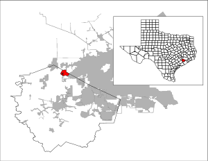
Cinco Ranch is a census-designated place and master-planned community located in the extraterritorial jurisdiction of the city of Houston within Fort Bend and Harris counties in the U.S. state of Texas. The population was 18,274 at the 2010 census. It lies about 25 miles (40 km) west of the Harris County seat of Houston and 10 miles (16 km) north of the Fort Bend County seat of Richmond. Cinco Ranch is considered to be part of the Greater Katy area and is roughly 10 miles southeast of the city of Katy.
The Cinco Ranch community goes back to before Texas became a republic. In the 1820s, pioneer Moses Austin was granted by the Spanish government the authority to settle 300 families in the valleys of the Brazos and Colorado rivers. He died before he was able to accomplish this, but his son Stephen F. Austin was able to complete his father's wishes, even under the newly established Mexican government. One of the men who moved into these 300 slots of land (each one over 4,000 acres/16 km2) was Randolph Foster, whose land spread across Fort Bend and Waller counties and upon which wild horses, deer, Native Americans and buffalo lived.
...
Wikipedia


