Choa Chu Kang
| Choa Chu Kang | ||||||
|---|---|---|---|---|---|---|
| Planning Area and HDB Town | ||||||
| Other transcription(s) | ||||||
| • Chinese | 蔡厝港 | |||||
| • Pinyin | Cài Cuò Gǎng | |||||
| • Hokkien | Chha-chhu-káng | |||||
| • Malay | Choa Chu Kang | |||||
| • Tamil | சுவா சூ காங் | |||||
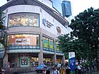
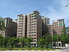
From top left to right: ITE College West, Lot One Shoppers' Mall, Flats in Choa Chu Kang, Condominium flats near Choa Chu Kang MRT/LRT Station
|
||||||
| Location of Choa Chu Kang within Singapore | ||||||
| Coordinates: 1°23′N 103°45′E / 1.383°N 103.750°E | ||||||
| Country |
|
|||||
| Region |
|
|||||
| CDCs | ||||||
| Town Councils |
|
|||||
| Constituencies | ||||||
| Government | ||||||
| • Mayors |
North West CDC South West CDC |
|||||
| • Members of Parliament |
Chua Chu Kang GRC Marsiling-Yew Tee GRC |
|||||
| Area | ||||||
| • Total | 6.11 km2 (2.36 sq mi) | |||||
| • Residential | 3.07 km2 (1.19 sq mi) | |||||
| Population (2015) | ||||||
| • Total | 174,330 | |||||
| • Density | 29,000/km2 (74,000/sq mi) | |||||
| Demonym(s) |
Official
Colloquial
|
|||||
| Ethnic groups | ||||||
| • Chinese | 123,450 | |||||
| • Malays | 29,630 | |||||
| • Indians | 16,470 | |||||
| • Others | 4,790 | |||||
| Postal district | 23 | |||||
| Dwelling units | 42,393 | |||||
| Projected ultimate | 62,000 | |||||
North West CDC
South West CDC
Chua Chu Kang GRC
Marsiling-Yew Tee GRC
Official
Colloquial
Choa Chu Kang (Chinese: 蔡厝港, Tamil: சுவா சூ காங்), alternatively spelt as Chua Chu Kang and often abbreviated as CCK, is a planning area and residential town located at the north-westernmost point of the West Region of Singapore. The town shares borders with Sungei Kadut to the north, Tengah to the southwest, Bukit Batok to the southeast, Bukit Panjang to the east and the Western Water Catchment to the west. Choa Chu Kang New Town is separated into two portions by the Kranji Expressway.
Originally a kampung, the area has been rapidly developed under the ambition of the Housing and Development Board, to transform it into a modern township. The town comprises seven subzones, four of which are the most densely populated: Choa Chu Kang Central, Choa Chu Kang North, Yew Tee and Teck Whye.
Choa Chu Kang's name is derived from its historical core at the former site of Chua Chu Kang Village located near the junction of Choa Chu Kang Road and Jalan Sungei Poyan, currently occupied by the grounds of the National Shooting Centre which comes under the purview of Singapore Shooting Association. The name began to be applied to the general area around the village when Choa Chu Kang Road, a main arterial road linking the village to Upper Bukit Timah Road towards the east was built.
...
Wikipedia


