Castroville, Texas
| Castroville, Texas | ||
|---|---|---|
| City | ||

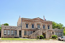
Castroville City Hall
|
||
|
||
| Nickname(s): The Little Alsace of Texas | ||
 Location of Castroville, Texas |
||
 |
||
| Coordinates: 29°21′N 98°53′W / 29.350°N 98.883°WCoordinates: 29°21′N 98°53′W / 29.350°N 98.883°W | ||
| Country | United States | |
| State | Texas | |
| County | Medina | |
| Area | ||
| • Total | 2.6 sq mi (6.6 km2) | |
| • Land | 2.5 sq mi (6.6 km2) | |
| • Water | 0.0 sq mi (0.0 km2) | |
| Elevation | 758 ft (231 m) | |
| Population (2000) | ||
| • Total | 2,664 | |
| • Density | 1,045.4/sq mi (403.6/km2) | |
| Time zone | Central (CST) (UTC-6) | |
| • Summer (DST) | CDT (UTC-5) | |
| ZIP codes | 78009, 78023 | |
| Area code(s) | 830 | |
| FIPS code | 48-13312 | |
| GNIS feature ID | 1353948 | |
Castroville is a city in Medina County, Texas, United States. The population was 2,680 at the 2010 census. Prior to 1893, Castroville was the first county seat of Medina County.
Castroville is part of the San Antonio Metropolitan Statistical Area.
Castroville was established in 1844 by Henri Castro, an empresario of the Republic of Texas, who brought several dozen European families to the area from Alsace and adjoining Baden to populate his land grant along the Medina River 20 miles west of San Antonio. The first colonists disembarked at Galveston on January 9, 1843. They were taken by ship to Lavaca Bay and traveled overland to San Antonio, where they took shelter in abandoned buildings until the Texas Rangers were prepared to escort them to their land and protect them from hostile Indians. On September 2, 1844, the first colonists arrived at Castro's land grant on the Medina River.
From 1849, Castroville, on the Medina River was a water stop on the San Antonio-El Paso Road and a stagecoach station on the San Antonio-El Paso Mail Line and San Antonio-San Diego Mail Line.
...
Wikipedia

