Carlingford, County Louth
|
Carlingford Cairlinn
|
|
|---|---|
| Town | |

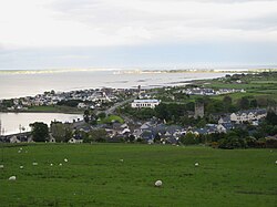
Carlingford Town from above
|
|
| Location in Ireland | |
| Coordinates: 54°02′35″N 6°11′10″W / 54.04294°N 6.18609°WCoordinates: 54°02′35″N 6°11′10″W / 54.04294°N 6.18609°W | |
| Country | Ireland |
| Province | Leinster |
| County | County Louth |
| Elevation | 1 m (3 ft) |
| Population (2011) | |
| • Urban | 1,045 |
| Irish Grid Reference | J185115 |
Carlingford (from Old Norse Kerlingfjǫrðr, meaning 'narrow sea-inlet of the hag';Irish: Cairlinn) is a coastal town and townland in northern County Louth, Ireland. It is situated between Carlingford Lough (to the east) and Slieve Foy, sometimes known as Carlingford Mountain (to the west), It is located within the Cooley Peninsula. Located on the R176/R173 roads between Greenore Point and Omeath village, Carlingford is approximately 27 km north east (by road) from Dundalk (15.6 km directly), 90 km north of Dublin and 11 km south of the border with Northern Ireland. Carlingford won the Irish Tidy Towns Competition in 1988.
Carlingford has a number of mediaeval streets — the main one being Tholsel Street which holds the remnants of an old Toll Gate and a Mint.
Carlingford was occupied in the 12th century by Norman knight Hugh de Lacy after laying the foundation stone for a castle on a strategic outcrop of rock. A settlement sprang up close to this fortress. The construction of this castle is ascribed by tradition to King John about the year 1210. The castle is an extensive ruin seated on a solid rock - the sides of which are enclosed by the sea. Mountains rise on the inland side, at the foot of which is a narrow pass which was formerly commanded by the fortress.
...
Wikipedia

