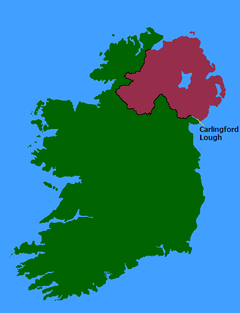
Carlingford Lough
| Carlingford Lough Loch Cairlinn Carlinford / Cairlinfurd Loch |
|
|---|---|
 |
|
 |
|
| Location | Republic of Ireland – United Kingdom border |
| Coordinates | 54°04′24″N 6°11′58″W / 54.07329°N 6.19938°WCoordinates: 54°04′24″N 6°11′58″W / 54.07329°N 6.19938°W |
| River sources | Newry River, Newry Canal |
| Ocean/sea sources | Irish Sea |
| Basin countries |
Northern Ireland, Republic of Ireland |
| Salinity | 31.31–33.99 psu |
| Settlements | Carlingford, Greencastle, Greenore, Killowen, Newry, Omeath, Rostrevor, Warrenpoint |
| Designated | 9 March 1998 |
Carlingford Lough (Irish: Loch Cairlinn; Ulster Scots: Carlinford Loch or Cairlinfurd Loch) is a glacial fjord or sea inlet that forms part of the border between Northern Ireland to the north and the Republic of Ireland to the south. On its northern shore is County Down and on its southern shore is County Louth. At its extreme interior angle (the northwest corner) it is fed by the Newry River and the Newry Canal.
The name is derived from the Old Norse Kerlingfjǫrðr, which means "narrow sea-inlet of the hag". Historically it was called Cuan Snámh-Aighneach, Snámh-Aighneach or Cuan Cairlinne in Irish. An older English name was Nury (Newry) Bay.
The Newry River and the Newry Canal link the lough to the nearby city of Newry (the canal continues on towards the River Bann and Lough Neagh; the river, under the name River Clanrye, loops around County Down). The only other glacial fjords in Ireland are Lough Swilly and Killary Harbour.
On the northern coast, in County Down, are the coastal towns of Warrenpoint and Rostrevor, backed by the Mourne Mountains. On the southern coast are Omeath, Carlingford and Greenore backed by the Cooley Mountains, all on the Cooley Peninsula in County Louth.
...
Wikipedia
