Northern Ireland
|
Northern Ireland |
|
|---|---|

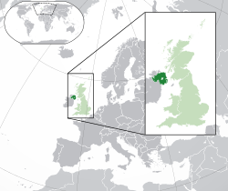
Location of Northern Ireland (dark green)
– in Europe (green & dark grey) |
|
| Status | Country |
| Capital and largest city |
Belfast 54°36′N 5°55′W / 54.600°N 5.917°W |
| Languages | English |
| Regional languages |
|
| Ethnic groups (2011) | |
| Type | Constituent unit |
|
|
| Government | Consociational devolved legislature within unitary constitutional monarchy |
|
• Monarch
|
|
|
Vacant
|
|
|
Vacant
|
|
| Parliament of the United Kingdom | |
| Theresa May | |
| James Brokenshire | |
| 18 MPs (of 650) | |
| Legislature | Northern Ireland Assembly |
| Devolution | |
| 3 May 1921 | |
| 18 July 1973 | |
| 17 July 1974 | |
| 19 November 1998 | |
| Area | |
|
• Total
|
14,130 km2 (5,460 sq mi) |
| Population | |
|
• 2017 estimate
|
1,868,700 |
|
• 2011 census
|
1,810,863 |
|
• Density
|
132/km2 (341.9/sq mi) |
| GDP (PPP) | 2014 estimate |
|
• Total
|
€41 billion |
|
• Per capita
|
€22,400 |
| GDP (nominal) | 2014 estimate |
|
• Total
|
€42 billion |
|
• Per capita
|
€23,400 |
| Currency | Pound sterling (GBP) |
| Time zone | GMT (UTC) |
|
• Summer (DST)
|
BST (UTC+1) |
| Date format | dd/mm/yyyy (AD) |
| Drives on the | left |
| Calling code | +44 |
| ISO 3166 code | GB-NIR |
|
|
| Cities and towns by population | ||||||
|---|---|---|---|---|---|---|
| # | Settlement | Population | Metro population | |||
| 1 | Belfast | 276,705 | 579,726 | |||
| 2 | Derry | 83,652 | 90,663 | |||
| 3 | Lisburn | 71,403 | ||||
| 4 | Newtownabbey | 62,022 | ||||
| 5 | Bangor | 58,368 | ||||
| 6 | Greater Craigavon | 57,651 | ||||
| 7 | Castlereagh | 54,636 | ||||
| 8 | Ballymena | 28,704 | ||||
| 9 | Newtownards | 27,795 | ||||
| 10 | Newry | 27,300 | ||||
– in Europe (green & dark grey)
– in the United Kingdom (green)
Northern Ireland (Irish: Tuaisceart Éireann [ˈt̪ˠuəʃcəɾˠt̪ˠ ˈeːɾʲən̪ˠ]; Ulster Scots: Norlin Airlann) is a top-level constituent unit of the United Kingdom in the northeast of Ireland. It is variously described as a country, province, region, or "part" of the United Kingdom, amongst other terms. Northern Ireland shares a border to the south and west with the Republic of Ireland. In 2011, its population was 1,810,863, constituting about 30% of the island's total population and about 3% of the UK's population. Established by the Northern Ireland Act 1998 as part of the Good Friday Agreement, the Northern Ireland Assembly holds responsibility for a range of devolved policy matters, while other areas are reserved for the British government. Northern Ireland co-operates with the Republic of Ireland in some areas, and the Agreement granted the Republic the ability to "put forward views and proposals" with "determined efforts to resolve disagreements between the two governments".
Northern Ireland was created in 1921, when Ireland was partitioned between Northern Ireland and Southern Ireland by an act of the British parliament. Unlike Southern Ireland, which would become the Irish Free State in 1922, the majority of Northern Ireland's population were unionists, who wanted to remain within the United Kingdom, most of whom were the Protestant descendants of colonists from Great Britain; however, a significant minority, mostly Catholics, were nationalists who wanted a united Ireland independent of British rule. Today, the former generally see themselves as British and the latter generally see themselves as Irish, while a distinct Northern Irish or Ulster identity is claimed both by a large minority of Catholics and Protestants and by many of those who are non-aligned.
...
Wikipedia


