Craigavon
Craigavon
|
|
|---|---|
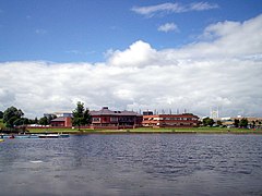
 Craigavon Civic Centre from Craigavon Lakes |
|
| Craigavon shown within Northern Ireland | |
| Population | 16,000 (2011 estimate) |
| Irish grid reference | J042562 |
| • Belfast | 21 miles (34 km) |
| District | |
| County | |
| Country | Northern Ireland |
| Sovereign state | United Kingdom |
| Post town | CRAIGAVON |
| Postcode district | BT62, BT63, BT64, BT65, BT66, BT67 |
| Dialling code | 028 38, +44 28 |
| Police | Northern Ireland |
| Fire | Northern Ireland |
| Ambulance | Northern Ireland |
| EU Parliament | Northern Ireland |
| NI Assembly | |
| Website | www.craigavon.gov.uk |
Craigavon (pronounced krayg-AV-ən; Irish: Creag Abhann [ˈcɾʲaɡˈawən̪ˠ]) is a planned settlement in north County Armagh, Northern Ireland. Its construction began in 1965 and it was named after Northern Ireland's first Prime Minister: James Craig, 1st Viscount Craigavon. It was intended to be the heart of a new linear city incorporating Lurgan and Portadown, but this plan mostly failed and less than half of the proposed work was finished. Among locals today, "Craigavon" refers to the area between the two towns. It is built beside two artificial lakes and is made up of a large residential area (Brownlow), a second smaller one (Mandeville), plus a central area (Highfield) that includes a substantial shopping centre, a courthouse and the district council headquarters. The lakes, a wildlife haven, are surrounded by woodland with walking trails. There is also a watersports centre, petting zoo, golf course and ski slope in the area. In most of Craigavon, motor vehicles are completely separated from pedestrians, and roundabouts are used extensively.
Craigavon sometimes refers to the much larger Craigavon Urban Area, which includes Craigavon, Lurgan, Portadown, Waringstown and Bleary.
Craigavon was planned as a 'new city' for Northern Ireland that would mirror cities such as Milton Keynes in Great Britain. It was conceived as a linear city that would link the towns of Lurgan and Portadown to create a single urban area and identity. The argument for a new town was based on projections indicating population increases over the following decades that would require large-scale house building. Similar projects had been successfully completed in Great Britain so it was in some ways a symbol of Northern Ireland as both modern and a part of the British mainstream. The Craigavon Development Commission was appointed in October 1965 to develop the 'new city'. About 6,000 acres of land between Lurgan and Portadown was vested from farmers at £6 an acre. Several reasons have been suggested for the suitability of the site including the existing population centres, industrial base, nearness to Belfast and the belief that Craigavon would help spread development away from Belfast. It was hoped that residents of Belfast would be attracted by the suburban nature of Craigavon's design and that business would see it as an interesting alternative. Cash incentives were offered to some families moving to Craigavon. The M1 motorway was built to link the new city with Belfast and there were plans to replace the Lurgan and Portadown railway stations with a single high speed terminal in central Craigavon. The Craigavon Area Hospital was built to replace small hospitals in the two towns.
...
Wikipedia

