Republic of Ireland-United Kingdom border
| Republic of Ireland–United Kingdom border | |
|---|---|

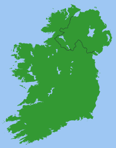
A map showing the Republic of Ireland – United Kingdom border.
|
|
| Characteristics | |
| Entities | |
| Length | 499 km (310 mi) |
| History | |
| Established | 3 May 1921 |
| Partition of Ireland | |
| Current shape | 7 December 1922 |
| Northern Ireland opt out of the Free State | |
| Treaties | Anglo-Irish Treaty |
| Notes | Open border not officially marked by either government |
The Republic of Ireland–United Kingdom border (referred to as the Irish border or in Ireland simply as the border) is the boundary between the Republic of Ireland and Northern Ireland (which remains part of the United Kingdom).
The border runs for a total of 499 km (310 mi) from Lough Foyle in the north of Ireland to Carlingford Lough in the northeast (on the Irish Sea), separating the Republic from Northern Ireland. The Irish border is considered one of the most atypical of international boundaries, in terms of its historical origins, geographical context, and administrative regime.
Border markings are comparatively inconspicuous, in common with many international borders in the European Union although, unlike many other EU borders, there are no signposts at crossing points notifying travellers that they are entering a different jurisdiction. While both states are outside the European Union's Schengen Area, they do share a Common Travel Area, resulting in an essentially open border since 1923. There are more than 200 public roads that cross the border.
Originally intended as an internal boundary within the United Kingdom of Great Britain and Ireland, the border was created in 1921 under the United Kingdom Parliament's Government of Ireland Act 1920. Prior to this, a separatist Irish parliament had been established in Dublin, which did not recognise the Government of Ireland Act, and was actively engaged in the Irish War of Independence. The Act was intended to deliver Home Rule in Ireland, with separate parliaments for Southern Ireland and Northern Ireland. Six of the thirty-two counties of Ireland were assigned to Northern Ireland, and the rest of Ireland comprising 26 counties to Southern Ireland.
...
Wikipedia
