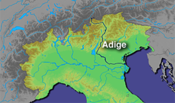
Adige River
| Adige | |
| Etsch, Àdexe, Adesc, Athesis | |
| River | |
| Country | Italy |
|---|---|
| Cities | Glurns, Merano, Bolzano, Auer, Trento, Rovereto, Verona |
| Source | Reschen Pass |
| - location | Graun im Vinschgau, South Tyrol, Italy |
| - elevation | 1,520 m (4,987 ft) |
| - coordinates | 46°50′04″N 10°30′53″E / 46.83444°N 10.51472°E |
| Mouth | Adriatic Sea |
| - coordinates | 45°8′59″N 12°19′13″E / 45.14972°N 12.32028°ECoordinates: 45°8′59″N 12°19′13″E / 45.14972°N 12.32028°E |
| Length | 410 km (255 mi) |
| Basin | 12,100 km2 (4,672 sq mi) |
| Discharge | |
| - average | 235 m3/s (8,299 cu ft/s) |
|
Map of Adige River
|
|
The Adige (Italian pronunciation: [ˈaːdidʒe]; German: Etsch [ɛtʃ]; Venetian: Àdexe; Romansh: ![]() Adisch ; Ladin: Adesc; Latin: Athesis; Ancient Greek: Ἄθεσις) is a river with its source in the Alpine province of South Tyrol near the Italian border with Austria and Switzerland. At 410 kilometres (250 mi) in length, it is the second longest river in Italy, after the Po river at 652 kilometres (405 mi).
Adisch ; Ladin: Adesc; Latin: Athesis; Ancient Greek: Ἄθεσις) is a river with its source in the Alpine province of South Tyrol near the Italian border with Austria and Switzerland. At 410 kilometres (250 mi) in length, it is the second longest river in Italy, after the Po river at 652 kilometres (405 mi).
The river sources near the Reschen Pass (1,504 metres (4,934 ft)) close to the borders with Austria and Switzerland above the Inn valley. It flows through the artificial alpine Lake Reschen. The lake is known for the church tower that marks the site of the former village of Alt Graun ("Old Graun"); it was evacuated and flooded in 1953 after the dam was finished. Near Glurns, the Rom river joins from the Swiss Val Müstair.
...
Wikipedia

