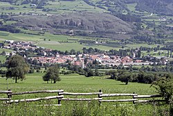
Glurns
| Glurns | ||
|---|---|---|
| Comune | ||
| Stadtgemeinde Glurns Comune di Glorenza |
||
 |
||
|
||
| Location of Glurns in Italy | ||
| Coordinates: 46°40′N 10°33′E / 46.667°N 10.550°ECoordinates: 46°40′N 10°33′E / 46.667°N 10.550°E | ||
| Country | Italy | |
| Region | Trentino-Alto Adige/Südtirol | |
| Province / Metropolitan city | South Tyrol (BZ) | |
| Government | ||
| • Mayor | Alois Frank | |
| Area | ||
| • Total | 13.0 km2 (5.0 sq mi) | |
| Elevation | 907 m (2,976 ft) | |
| Population (Nov. 2010) | ||
| • Total | 876 | |
| • Density | 67/km2 (170/sq mi) | |
| Demonym(s) | German:Glurnser Italian: glorenzini |
|
| Time zone | CET (UTC+1) | |
| • Summer (DST) | CEST (UTC+2) | |
| Postal code | 39020 | |
| Dialing code | 0473 | |
| Website | Official website | |
Glurns (German pronunciation: [ˈɡlʊrns]; Italian: Glorenza [ɡloˈrɛntsa]) is a comune (municipality) in South Tyrol in northern Italy, located about 80 kilometres (50 mi) northwest of Bolzano.
As of 30 November 2010, it had a population of 876 and an area of 13.0 square kilometres (5.0 sq mi).
Glurns borders the following municipalities: Mals, Prad am Stilfser Joch, Schluderns and Taufers im Münstertal.
The shield is party per pale: the first part represents half Tyrolean Eagle on argent; the second is tierced per fess of sable, argent and gules. The eagle represents the membership of the village to the Tyrol, while the colors sable, argent and gules are those of the city. The emblem was granted in 1528 by Ferdinand I, Holy Roman Emperor.
According to the 2011 census, 96.13% of the population speak German and 3.87% Italian as first language.
...
Wikipedia


