Prad am Stilfser Joch
| Prad am Stilfser Joch | |
|---|---|
| Comune | |
| Marktgemeinde Prad aSJ Comune di Prato aS |
|

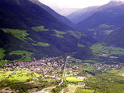
The village viewed from north
|
|
| Location of Prad am Stilfser Joch in Italy | |
| Coordinates: 46°37′N 10°36′E / 46.617°N 10.600°ECoordinates: 46°37′N 10°36′E / 46.617°N 10.600°E | |
| Country | Italy |
| Region | Trentino-Alto Adige/Südtirol |
| Province / Metropolitan city | South Tyrol (BZ) |
| Frazioni | Lichtenberg (Montechiaro) |
| Government | |
| • Mayor | Karl Bernhart |
| Area | |
| • Total | 51.4 km2 (19.8 sq mi) |
| Elevation | 915 m (3,002 ft) |
| Population (Dec. 2015) | |
| • Total | 3.474 |
| • Density | 0.068/km2 (0.18/sq mi) |
| Demonym(s) | German: Prader Italian: pratesi |
| Time zone | CET (UTC+1) |
| • Summer (DST) | CEST (UTC+2) |
| Postal code | 39026 |
| Dialing code | 0473 |
| Website | Official website |
Prad am Stilfser Joch (German pronunciation: [praˑt am ˈʃtɪlfsɐ jɔx]; Italian: Prato allo Stelvio [ˈpraːto ˈallo ˈstɛlvjo]), often abbreviated to Prad or Prato, is a comune (municipality) in South Tyrol in northern Italy, located about 60 kilometres (37 mi) west of the city of Bolzano, on the border with Switzerland, and near the Stelvio Pass.
As of 31 December 2015, it had a population of 3,474 and an area of 51.4 square kilometres (19.8 sq mi).
The municipality of Prad contains the frazione (subdivision) Lichtenberg (Montechiaro).
Prad borders the following municipalities: Glurns, Laas, Schluderns, Stilfs, Taufers im Münstertal and Müstair (Switzerland).
The emblem shows three or ears of wheat, in a gules field on azure. The bottom is red. The wheat symbolizes the importance played by the cereal growing in the municipality. The emblem was adopted in 1969.
According to the 2011 census, 97.21% of the population speak German, 2.73% Italian and 0.06% Ladin as first language.
...
Wikipedia

