2013 North Indian Ocean cyclone season
| 2013 North Indian Ocean cyclone season |
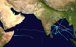
Season summary map
|
| Seasonal boundaries |
| First system formed |
May 10, 2013 |
| Last system dissipated |
December 13, 2013 |
| Strongest storm |
|
| Name |
Phailin |
| • Maximum winds |
215 km/h (130 mph)
(3-minute sustained) |
| • Lowest pressure |
940 hPa (mbar) |
| Seasonal statistics |
| Depressions |
10 |
| Deep depressions |
6 |
| Cyclonic storms |
5 |
| Severe cyclonic storms |
4 |
| Very severe cyclonic storms |
3 |
| Total fatalities |
323 total |
| Total damage |
At least $1.5 billion (2013 USD) |
| Related articles |
|
|
North Indian Ocean tropical cyclone seasons
2011, 2012, 2013, 2014, 2015
|
| Cyclonic storm (IMD) |
| Tropical storm (SSHWS) |
|
|
| Duration |
May 10 – May 17 |
| Peak intensity |
85 km/h (50 mph) (3-min) 990 hPa (mbar) |
| Depression (IMD) |
|
|
| Duration |
May 29 – May 31 |
| Peak intensity |
45 km/h (30 mph) (3-min) 990 hPa (mbar) |
| Depression (IMD) |
|
|
| Duration |
July 30 – August 1 |
| Peak intensity |
45 km/h (30 mph) (3-min) 990 hPa (mbar) |
| Depression (IMD) |
|
|
| Duration |
August 20 – August 23 |
| Peak intensity |
45 km/h (30 mph) (3-min) 990 hPa (mbar) |
| Extremely severe cyclonic storm (IMD) |
| Category 5 tropical cyclone (SSHWS) |
|
|
| Duration |
October 8 (Entered basin on Oct. 6) – October 14 |
| Peak intensity |
215 km/h (130 mph) (3-min) 940 hPa (mbar) |
| Deep depression (IMD) |
| Tropical storm (SSHWS) |
|
|
| Duration |
November 8 – November 11 |
| Peak intensity |
55 km/h (35 mph) (3-min) 1002 hPa (mbar) |
| Depression (IMD) |
| Tropical storm (SSHWS) |
|
|
| Duration |
November 13 (Entered basin on Nov. 8) – November 17 |
| Peak intensity |
45 km/h (30 mph) (3-min) 1003 hPa (mbar) |
| Severe cyclonic storm (IMD) |
| Category 1 tropical cyclone (SSHWS) |
|
|
| Duration |
November 19 – November 23 |
| Peak intensity |
100 km/h (65 mph) (3-min) 990 hPa (mbar) |
| Very severe cyclonic storm (IMD) |
| Category 1 tropical cyclone (SSHWS) |
|
|
| Duration |
November 23 (Entered basin) – November 28 |
| Peak intensity |
140 km/h (85 mph) (3-min) 980 hPa (mbar) |
The 2013 North Indian Ocean cyclone season was an event in the annual cycle of tropical cyclone formation, in which tropical cyclones formed in the North Indian Ocean and Arabian Sea. The season had no official bounds, but cyclones typically formed between May and December, with the peak from October to November. These dates conventionally delimit the period of each year when most tropical cyclones form in the northern Indian Ocean.
The scope of this article is limited to the Indian Ocean in the Northern Hemisphere, east of the Horn of Africa and west of the Malay Peninsula. There are two main seas in the North Indian Ocean — the Arabian Sea to the west of the Indian subcontinent, abbreviated ARB by the India Meteorological Department (IMD); and the Bay of Bengal to the east, abbreviated BOB by the IMD.
The official Regional Specialized Meteorological Centre in this basin is the India Meteorological Department (IMD), while the Joint Typhoon Warning Center releases unofficial advisories. On average, 4 to 6 storms form in this basin every season.
After a five-month break in tropical cyclone activity over the basin, the first depression of the year developed over the southern Bay of Bengal on May 10, 2013. The system subsequently developed into Cyclonic Storm Viyaru during May 12, before it made landfall near Chittagong, Bangladesh during May 16. As a result of the formation of Viyaru, the low level equatorial monsoon flow strengthened over southern parts of the North Indian Ocean, which in turn allowed the south-west monsoon to set in over the Andaman Sea and parts of the Bay of Bengal during May 17. A depression developed and made landfall on West Bengal, during May 29, before it was last noted during May 31. During June 1, the south-west monsoon set in over Kerala, the Maldives and parts of the south and central Arabian Sea. Over the next two weeks one of the fastest onsets of the monsoon over India was observed After the monsoon had set in over Kerala, one of the fastest onsets of the monsoon over India was observed, with the whole nation covered by June 16 or about a month earlier than normal. Reasons for the fast onset included a favourable phase of the Madden-Julian Oscillation and the west-northwest movement of an area of low pressure between June 12–16.
...
Wikipedia


